Antes de viajar al Parque Natural de Cabo de Gata desconocía su pasado volcánico. Hace 16 millones de años esta zona estaba bajo el agua y cuando chocaron las placas africana y euroasiática se crearon los volcanes. Estos tres paseos tienen un vínculo con este pasado.
Before visiting the Cabo de Gata Natural Park I was unaware of its volcanic past. 16 million years ago South-East Spain was under water and when the African and Eurasian tectonic plates collided, volcanoes were formed. These three walks have a link with that past.
1. El Cerro del Hoyazo
Durante nuestra estancia vi referencias a un cráter cerca de Níjar, resultado de un volcán submarino. La actividad volcánica tuvo como consecuencia la mineralización de la zona y en este caso concreto muchos granates almandinos subieron a la superficie. Las piedras se minaban en el siglo XX y todavía se encuentran trocitos de esta piedra en la base del cráter.
During our stay I read that there was a crater, which was formerly an underwater volcano, near the town of Níjar. Volcanic eruptions led to lots of minerals reaching the surface - in this case almandine garnets. These stones were mined in the 20th century and you can find small pieces of the stone today at the base of the crater.
Llamado el volcán de la Granatilla, se señala en algunos mapas turísticos pero no hay ninguna indicación en el lugar para encontrar el sitio. En la oficina de turismo de Níjar sólo podían decirme que estaba al salir del pueblo pasando el cementerio. Que conste que el pueblo de Níjar bien merece una visita - aquí se ve desde la Atalaya. Al fondo está el mar de plástico que constituyen los campos de hortalizas de Campohermoso y lugares cercanos.
The Granatilla volcano, as it's called, appears on several maps of the area but is not signposted. All they could tell me at the Níjar tourist office was that it was on the outskirts of town just past the cemetery. Incidentally, Nijar - seen here from the look-out tower - is well worth a visit. In the distance is a sea of plastic made up of miles of greenhouses in the Campohermoso area, which provide vegetables for export to European markets.

Según algún blog que había visto, para llegar a la Granatilla era necesario coger una pista de tierra unos doscientos metros antes de la autovía A-7. Efectivamente, después de pasar el cementerio, a mano izquierda saliendo de la AL-3106 hay una pista que se bifurca en seguida. El ramal de la izquierda se dirige a un cortijo que se ve un poco más adelante, así que hay que seguir el de la derecha Se puede circular con coche por la pista, que va en paralelo a la carretera durante 1,2 kilómetros. Al fondo se ve claramente la apertura en el borde del cerro del Hoyazo que da acceso al cráter. De hecho se distingue el sendero que sube hasta ahí.
Anyway, according to blogs I'd seen, to get to the Granatilla volcano you had to take a dirt track about 200mts before the Murcia-Almería dual-carriageway. Just after the cemetery the track leads off the AL-3106 road to the left. Take the right-hand fork and follow it for just over a kilometre till you get to a place where you can leave your car if you're driving. In the photo you can see the opening on the Hoyazo hill rim that leads to the crater. You can even make out the path that leads up the slope.

El acceso al cráter es evidente
This is the view from below the access to the crater

Ya sólo hay que subir la senda empinada y bajar por el otro lado para encontrarte dentro de un volcán extinto, lo que me hizo bastante ilusión. También se encuentra piezas pequeñísimas de granate por todas partes que explican el nombre de Granatilla.
All you have to do is walk up the steepish path and down the other side and you're inside an extinct volcano. There are also lots of small dark-red garnets lying everywhere, which explain the name Granatilla

En el centro hay los restos del pitón volcánico
In the centre is the volcanic rock marking the spot where the lava would have flowed from

from there you can see the entrance to the crater and beyond. The edges of the crater rim are coral reef remains.

2. El Cerro Negro
El aspecto volcánico también se ve en algunas rocas que jalonan el paisaje del Cabo de Gata. Por ejemplo, el color de Cerro Negro contrasta con la duna fosilizada de la playa del Playazo que se ve delante. A la izquierda de la duna está el Castillo de San Román.
The Cabo de Gata landscape is also dotted with rocks that are clearly volcanic in origin. For example the dark Cerro Negro stands out against the fossilised dunes near the Playazo beach.

Para subir al cerro hay que acercarse a la playa del pueblo de Las Negras (que debe su nombre a la roca). Esta foto se sacó otro día con un oleaje poco habitual.
To approach the Cerro Negro (Black Hill) you need to go to Las Negras beach. This photo was taken on a different day.

Seguí la playa a la izquierda hasta dar con la rambla que aparece en la parte izquierda de la foto. Se sigue unos minutos hasta que conecte con una pista que sube hacia la derecha.
I followed the beach to the left and then turned up the dry watercourse on the left of the photo. You walk along this for a few minutes before joining the track that leads up to the right.

Subes la pista y la dejas cuando empieza a llanear antes de continuar a la cala de San Pedro. Luego hay que subir como se pueda (no hay camino). Yo continué en la misma dirección que venía para atacar la cresta desde el norte. Abajo se ve el pueblo de Las Negras
Follow the track up and leave it when it levels out prior to heading down to San Pedro cove. You then have to make your way up the hillside as best you can (there's no path). I carried on in the same direction I'd been going so as to approach the ridge from the north. Below is Las Negras (named after the hill)

Había un viento fortísimo, y seguir por la arista hasta el punto más alto habría sido imprudente
A very strong wind was blowing and prevented me from carrying on to the highest point of the ridge

Una mirada a mi izquierda antes de volver sobre mis pasos
A look down to the left before heading back

3. El Cerro de Los Lobos
Si vas desde Las Negras, la siguiente salida de la carretera (dirección La Isleta del Moro) después de la que va al Playazo indica el Faro de la Polacra. Se puede seguir un rato en coche antes de continuar a pie. En lugar de andar por el camino asfaltado seguí una senda a la derecha de la misma (hay otra a la izquierda). Esta senda va en línea recta hacia la Torre de los Lobos, convertido en el faro de mayor elevación de España. Cuando la torre aparece enfrente hay que bajar la cuesta hasta el camino para luego seguir subiendo por otra senda. No pasa nada ya que es un paseo corto, pero ¡no me apetecería hacerlo en verano!
On the road to Isleta del Moro (from Las Negras) just after the side road that goes to the beautiful Playazo beach is another, signposted to the Polacra Lighthouse. You can drive up it for a few minutes before a gate means you have to continue on foot. Instead of walking along the road thereafter I took a path on the right (there's another on the left) that goes straight towards the Torre de los Lobos tower, converted into the lighthouse standing at the highest elevation of any in Spain. The moment the tower came into view I realised I had to go down the hill again and get onto the road, only to leave it again almost immediately to take another path up the hill in front of me. No problem, as it's only a short walk, but I wouldn't fancy it with summer temperatures!

I wasn't too interested in the tower/lighthouse, but the views were lovely: to the south, the two domes of the cerro de los Frailes, which also began its existence as an underwater volcano

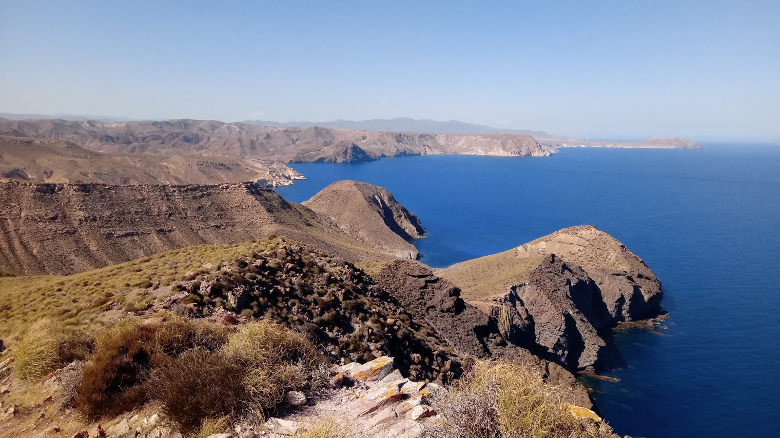
Mirando hacia el norte - se ve el Cerro Negro en el centro. A la derecha está la Punta de la Polacra. A propósito, lo de Cerro de Los Lobos se refiere a los lobos marinos que había por aquí.
Looking towards the north - Cerro Negro is in the centre. On the right is Polacra Point. This hill (Cerro de los Lobos) is named after the sealions that used to frequent the coast.
Hacia el interior está el valle de Rodalquilar, creado tras otra erupción volcánica. Al fondo a la izquierda se encuentran las antiguas minas de oro (otro ejemplo de la mineralización causada por la alteración hidrotermal) a que hace referencia Juan Goytisolo en su libro excelente "Campos de Níjar"
Inland is the Rodalquilar valley, formed after a massive volcanic eruption. In the background on the left were the old gold mines (another example of mineralisation following hydrothermal alteration) that are mentioned in Juan Goytisolo's excellent book "Campos de Níjar".

No hay comentarios:
Publicar un comentario
Please feel free to leave a comment!
¡Agradezco tus comentarios!