Mostrando entradas con la etiqueta Macizo de Arria. Mostrar todas las entradas

viernes, 28 de febrero de 2025

Juntando las piezas del puzzle / Completing the jigsaw

La ruta que hice a los pueblos de Lamasón en enero me recordó cuánto he disfrutado explorando el macizo de Arria hace unos años. Aproveché de un día festivo para recorrer la última parte de esta zona, que continúa hacia el oeste,  y subir al Gamonal, adonde fuimos hace tiempo desde Linares. De hecho tardé en darme cuenta de que este macizo de Arria es la prolongación de él de Peñarrubia. Como encajar las piezas de un gran puzzle topográfico. 

A walk in January reminded me how much I enjoyed exploring the Arria massif a few years ago. I took advantage of a holiday at work to get to know the part I hadn't covered, to the west, and return to Gamonal, a peak we had previously reached from the south-west. Actually, it had only recently dawned on me that the Arria massif is the continuation of one that I associated solely with the neighbouring district. Like fitting jigsaw pieces together to map out a bigger area.

Lo primero era localizar el collado por donde quería acceder. Cumbrialucu no se distingue desde el sur o el este como el amplio Tolaco, y sólo a través de fotos por satélite conseguí dar con un sendero. Los he marcado en esta primera foto, sacada desde cerca del Collado de Hoz, donde aparqué.

But first I had to work out how to get to the Cumbrialucu pass, which is not visible from below, and thanks to satellite images I reckoned I'd found a path. In the photo I've marked it and also the one I came back through.


Lafuente, valle abajo, debajo de Abidules
Lafuente, the village I've previously set off from, lower down the valley

Me alegré de encontrar un camino empedrado bastante cerca de la base de la ladera
I was pleased to find the path was where I'd hoped it'd be 


El collado se hace evidente desde bastante antes
It's pretty clear where the pass is some time before you get there

y llego debajo de un bonito cielo azul
and to add to the satisfaction a nice blue sky in the direction I would be heading

Última mirada atrás antes de traspasar las almenas
Last look back before I passed through the ramparts

Al otro lado se ve que estamos enfrente de la divisoria de Cantabria y Asturias
To the north the two estuaries show I'm near the border between Cantabria and Asturias 

Por suerte, vi un camino que subía hacia el oeste y después de seguirlo un poco, vi el Gamonal delante (es el monte de en medio de los tres)
My luck was in: I spotted a track leading up the hillside to the west, and it soon took me to a vantage point from which I could see Gamonal ahead of me (the middle of the three peaks)

Trazaba una ruta desde este alto juntando las cabañas que se veían
I followed the hillside round with the mostly abandoned huts like dots just waiting to be joined up

Los senderos que las conectaban se intuían fácilmente, y al poco estaba enfrente del primer alto
The paths that led from one to another weren't difficult to find and before long I was opposite the vantage point 

Bajé a esta zona herbosa, lugar donde iban a divergir los caminos de la ida y la vuelta
I walked down to this grassy field, where the outward and return legs were later to diverge

Después de una subida por terreno sucio llegué a un bonito valle al pie de los tres montes
Time to head up a hillside covered in scrub which brought me to this pretty spot at the foot of the three peaks

Cerca de la cima este árbol surgía de las rocas
Near the top this tree had sprouted from the boulders

los últimos metros, que dejan anticipar el premio del esfuerzo
the last part of the climb up presaged the reward I was about to receive

En el centro de la imagen se aprecia la zona herbosa cerca del alto mencionado
In the middle of the next photo the grassy area is where the vantage point from before is


Sierra de Peña Sagra

Roza (abajo) y La Cordillera al fondo

La cresta sigue hacia el collado las Llaves
Follow the ridge and you get to the Llaves pass
Los Picos de Europa

La costa se extendía hacia el este
The coastline stretching away to the east


Me gustaba especialmente el panorama desde Curavacas hasta el Coriscau
I particularly liked the view of the mountains near the Palencia-Cantabria border


Sin embargo, daban lluvia a partir de la tarde, y no pude demorar mucho en la cumbre.
As they'd forecast rain for the afternoon, I couldn't hang around too long.

Unas imágenes de la vuelta, un poco más hacia el norte que la ida
A few photos from the return leg, a little further to the north than the earlier route


Y llegué al collado Tolaco, desde donde se denomina Lafuente, los Pumares y Burió
And so I reached Tolaco pass, directly above Lafuente and its neighbouring hamlets
Paso debajo de La Cueva, monte que debe su nombre a la oquedad en su base
I turned right, walking past a summit called "The Cave" for fairly obvious reasons

Ya caían unas gotas mientras bajaba del collado, y al llegar al coche el macizo presentaba este aspecto
It started spitting with rain as I came down from the col, and by the time I got back to the car the massif was being engulfed by cloud


sábado, 11 de enero de 2025

Lamasón & Macizo de Arria (presente y pasado/present and past)

Uno de los placeres de andar por el monte es reconocer sitios montañosos visitados en salidas anteriores.
One of the pleasures of hiking is recognising mountainous areas you've been to on previous outings.

Esta ruta sencilla visitando los pueblos de Lamasón me ha recordado varias excursiones a la zona hace unos años. La primera que hice antes de llevar cámara terminó con un descenso arriesgado por la ladera del Macizo de Arria, que se ve en la primera foto. En las siguientes exploraciones desde este lado sur he descubierto dónde están los pasos cómodos.
This simple walk visiting villages in the west of Cantabria brought to mind various hikes in the area a few years ago. My introduction to the Arria massif, which you can see in the first photo, ended with a heart-in-my-mouth descent. Later explorations from this southern side enabled me to discover the safe passes.
Empecé esta primera ruta del 2025 en Quintanilla, cruzando el río Tanea. 
I began this first walk of 2025 in Quintanilla, crossing the Tanea river.

 En seguida llegué a Sobrelapeña
 Sobrelapeña is very near

Camino de Lafuente se ven las cimas nevadas de la Sierra de Peña Sagra
On the way to the next village, Lafuente, I caught the occasional glimpse of the snowcapped summits of the Peña Sagra Sierra


Bordeando el lado oriental del macizo, recuerdo una de las subidas que hice accediendo por el paso en la parte centro-derecha de la foto
Skirting the eastern side of the massif, I remember one of the walks I did up from the pass in the centre-right part of the photo


Claro, todavía hay que subir una rato hasta traspasar una portilla
Of course, you still have to go up a fair way, eventually reaching a gate 
01/2019

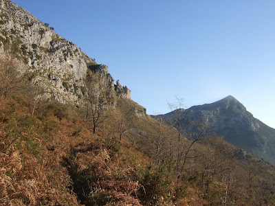
Se veía Peña Abidules al otro lado del río 
Abidules Peak on the other side of the river
01/2019

Arriba hay bastantes depresiones y varias cabañas, abandonadas en su mayoría
beyond which there are many depressions and stone huts, mostly abandoned
01/2019

01/2019

01/2019


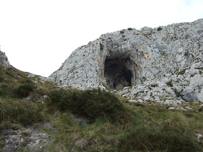
La primera subida que hice al macizo fue por La Canal de la Braña, a la izquierda de la oquedad en la roca
My very first walk up into the massif from this side though was via La Braña, to the left of the gaping hole in the rock
02/2016


Foto tomada desde la mitad de la subida por la canal
A photo taken from half way up 
02/2016

Desde la cresta se ve Lafuente abajo
From the top you see Lafuente down below
12/2016

Evidentamente hay mejores vistas a Peña Sagra
Better views of Peña Sagra
12/2016


Desde El Picu el Castillo mirando hacia el oeste
From El Castillo peak looking west
02/2016

Bajando hacia el Tolaco
Descending to Tolaco
01/2019


El collado de Tolaco es el paso más evidente de los que acceden a los Invernales de Arria. El Castillo está a la derecha de la foto
Tolaco is the most evident pass to get to the pasturelands on the other side. El Castillo is on the right of the photo

Acercándome al collado en diciembre de 2016
Approaching the pass in December 2016
Cdo. Tolaco

El Pico al lado oeste del collado es La Cueva. Desde allí se ve El Castillo en primer plano además de Peña Abidules al fondo
The peak on the west side of the pass is La Cueva. From here you can see the Castillo in the foreground and Abidules peak behind to the right
12/2016

Hacia el oeste: Los Picos de Europa
To the west lie the Picos de Europa
12/2016

y la continuación del macizo. El punto más alto es el Gamonal, que tengo en la lista para volver a subir, pero desde Lamasón en lugar de Peñarrubia
and the massif continues. The highest point is Gamonal. It's on my list to walk there from here
12/2016

12/2016


01/2019

La senda de Cumbrialucu lleva al caminante al lado sur del macizo 
This path leads to the southern side of the massif
12/2016


De nuevo en el 2025 estoy a punto de visitar Cires por vez primera. Al fondo Peña Abidules y los Picos de Ozalba, de los que forma parte
Back to 2025, I'm about to visit Cires for the first time. Beyond is Abidules and the Ozalba peaks, which it is part of
Cires

Hace unos años subí Los Picos de Ozalba en parte para obtener una perspectiva nueva sobre Arria
A few years ago I explored the Ozalba Peaks partly to obtain a new perspective of Arria


Entre Abidules (donde saqué esta foto) y el Macizo de Arria discurre el río Lamasón (o Tanea)
Between Abidules (where this photo was taken) and the Arria massif runs the Lamasón (or Tanea) river
02/2019

Desde Cires bajé a Río
From Cires I walked down to Río
Río

y tranquilamente seguí la carretera de vuelta a Quintanilla
and completed the walk along the road to Quintanilla
Quintanilla


Para acabar, otra foto desde Peña Abidules de los pueblos de Lamasón - Quintanilla queda justo fuera de la foto
Finally, another photo from Abidules showing the villages in Lamasón - Quintanilla is just out of shot