domingo, 30 de mayo de 2010

Peña Cortés (1)

The Pico Cortés is what looks as if it's the highest peak in this photo, with a rounded-looking summit, and the Prao Cortés to the right, with gentle incline from the left to the top, together form the Peña Cortés, one of the most important peaks of the Eastern Massif of the Picos de Europa. This photo was taken on a beautiful day in 2008 from the Horcadina de Covarrobres at the beginning of a walk to Peña Vieja, the highest peak entirely in Cantabria.
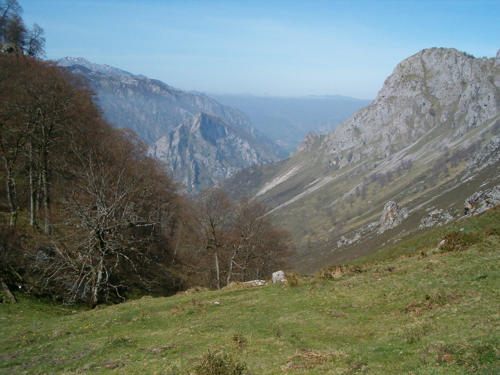
En esta foto parece que el pico más alto es el Cortés, con la cima redondeada. A su derecha está el Prao Cortés, con una subida suave desde la izq. Juntos forman la Peña Cortés, una de las cimas más importantes del macizo oriental de los Picos de Europa. Saqué esta foto un día de julio del 2008 desde la Horcadina de Covarrobres, nada más comenzar una subida a Peña Vieja, el pico más alto del macizo central enteramente en Cantabria.


Of course the weather conditions aren't always the same, as can be seen from another photo from the same spot a few months later:
Dos meses más tarde otra foto desde el mismo lugar, pero con un bonito mar de nubes


From the Manforas Mine at the start of the Canal del Vidrio you can make out the gap between the Peña Cortés and the Morra de Lechugales to the left
Desde la mina de Manforas en la base de la Canal del Vidrio se ve la división entre la Peña Cortés y la Morra de Lechugales a la izq.


and part of the way up the Canal the rock in the foreground seems to bisect the Pico from the Prao Cortés. Incidentally, the scree that can be seen just to the right of this rock is the route I was to take when ascending the Cortés
desde la Canal se ven el Pico y el Prao Cortés cada uno a un lado de la parte alta de la roca justo delante. La roca también parece que sigue la línea de ascención al Cortés


From higher up the division between the Pico Cortés and Morra is much clearer
Desde más arriba el hueco entre el Cortés y la Morra se ve más claramente


Another day, and yours truly on top of Torre Blanca, the highest point in the province, though also shared with León. Behind me to the right is Pico Santana and two thirds of the way to the end of the photo Peña Vieja. Between the two you can see the Morra de Lechugales (here clearly seen to be higher) and Pico Cortés.
Otro día, y un servidor está en la cima de Torre Blanca, el punto más alto de la provincia aunque compartido con León. Detrás de mí a la dcha. están el Pico Santana y más hacia la dcha. Peña Vieja. Entre ambos se distinguen la Morra (aquí se ve claramente que es más alto) y el Pico Cortés.


So, it was time to go up the Pico Cortés. I set off from Sotres in Asturias, up the track that divides the two glaciars all the way up to the Horcadina de Covarrobres, where the first two photos on this post were taken.
Llegó el día en que decidí subir el Cortés. Salí de Sotres en Asturias por la pista que hay entre los dos glaciares que separan el macizo oriental del central.


From the same point as the last photo, looking back the way I'd come
Desde el mismo lugar, pero mirando hacia el camino recorrido


Halfway along the track there's an enormous rock called the "castillo"
A la mitad de la pista que lleva a la Horcadina de Covarrobres hay una roca enorme que se llama el castillo


From here things didn't look promising, as cloud covered the upper part of the massif.
Desde aquí el día no prometía, ya que la parte alta de la cimera se escondía detrás de las nubes.


This is the view from about half way up, with the "castillo" clearly visible on the track
La vista desde la mitad de la subida, con el "castillo" encima de la pista


However, the cloud started to descend rather than lift, and I hadn't been on the scree slope long when it became clear that there was no point in continuing
Por desgracia la nube no se quitaba, más bien venía bajando, así que tuve que desistir


a momentary break in the cloud
se dejaba ver la Llomba del Toro durante unos segundos


and this was what would have lain before me had I been able to carry on
y mirando para arriba visibilidad cero


one last shot of the "castillo" as I headed back
una última foto del castillo mientras bajaba

sábado, 8 de mayo de 2010

Short walks Jan-Feb 2010/Caminatas cortas enero-febrero 2010

Casi nunca nieva en Bezana, pero al leventarme una mañana de enero vi que empezaba a cuajar; así se veía desde mi terraza:
It doesn't snow very often in Bezana but one Sunday in January it actually started to settle;
see view from my balcony:


decidí hacer una rutita de monte bajo por la nieve, saliendo de Puente Viesgo:
so I headed off for Puente Viesgo to take advantage of the snowy lanes at low altitude:


En el centro de la foto se aprecia el pico Dobra, que una vez subí desde Viérnoles, cerca de Torrelavega
In the centre of the photo is Pico Dobra, quite near Torrelavega


Desde la cima, mirando hacia Picos
From the top of Dobra, looking towards the Picos


Bajando, hacia Porracolina y Castro Valnera
On the way down, towards Castro Valnera


Otra de Castro Valnera a lo lejos
Castro Valnera again in the distance


En el mes de febrero caminé desde el Alto de Braguía por la divisoria entre los Valles de Toranzo y de Carriedo, y desde el Berana se ve también al Dobra, bastante más al norte:
In February I did a walk in the south of Cantabria, and from the highest point there's also a view of Pico Dobra, almost dead centre in the distance:


un par de fotos más - se veía mucho menos verde que lo habitual
a couple more shots from that walk

Desde aquí se ve Castro Valnera mucho más cerca:
This time I was a lot nearer Castro Valnera:


He hecho un par de rutas por la zona de Cabuérniga, pero no acompañaba el tiempo; aquí hay dos fotos del valle sacadas de sendas caminatas:
I've done a couple of walks to Cabuérniga, in central Cantabria, but the weather wasn't much good either time. The next two photos are of the Cabuérniga valley from two different angles:


Pero no siempre hay nubes, como demuestra esta vista de Entrambasaguas desde el Pico Vizmaya en febrero:
Just to show that it isn't always cloudy, here's a different valley, seen from the top of Pico Vizmaya, near Entrambasaguas in February:

domingo, 2 de mayo de 2010

Oceño - Cabeza Vigueras

Monday 26th April was "Fray Isidoro de Sevilla Day", a holiday at our centre, so I headed off to Oceño in Asturias for my first decent walk since getting tendinitis last summer.

My original idea was to go down the Rubó gorge to Trescares and get a taxi back up to Oceño, but the bar was closed, it being a Monday, so as I wouldn't be able to get the phone number for a taxi - and they'd have to come from Arenas anyway - I decided to start and finish in Oceño.


There had been constant fog all the way from Bezana, and I didn't get above it till about 800 mts, as you can see from the photos:


Once I got above the cloud level though, there were blue skies and good views. Here you can see the Braña de Carraspión


From the collado de Carraspión there would have been a great view of the collado de Galavín if the cloud coming up from the valley hadn't been about to hide it from view. Up to the left is Cabeza Vigueras, which I first went up last year, accessing Galavín from San Esteban, near the Hermida Gorge


From the Collada Cumpliceres there's a stunning view of the Naranjo de Bulnes, which my crappy camera can't do justice to, and the valley immediately below:


This is the same valley, but from the Collada Llamea, just opposite Galavín

You get to Collado Galavín walking round the head of the Rubó gorge.


The surroundings were very different to what I saw in February 2009, with the melting snow forming a waterfall:


Then up to the top of Cabeza Vigueras, which has views of Peña Sagra

the Macizo Oriental

and the Macizo Central


There's a "belén" at the summit. This view is of the valley leading down from Trespandiu, which I walked up later on:

the summit of Cabeza Vigueras from just below


I decided to go back via a different route, going down the upper part of the Rubó Gorge and then forking off to the left, up to Trespandiu. This is the head of the gorge, with collado Galavín behind


I kept to the left side; this is the view looking down the gorge


and back up to where it starts


This strange-looking rock marks the point where you leave the course of the riverbed and head to the left


A little further on, looking back up the valley


Back in Trespandiu, looking towards Cabeza Vigueras


and finally a picture of the village of Oceño

Altogether, it took about seven hours, and was a good walk, worthy of a first blog, I think.