lunes, 28 de septiembre de 2015

Pico Murcia


The first week of autumn and back to Palencia I went - a two-hour drive took me to a little village in the N-W of the province. As kids we used to pick rose hips and then try to catch our schoolmates out in a stupid ritual but I don't remember having seen a bush with quite as many as this one at the start of my walk.
Por segunda vez en una semana en Palencia; un trayecto de dos horas me llevó a Cardaño de Arriba. Ya estamos en otoño, y estos escaramujos añadían color al comienzo de la ruta.

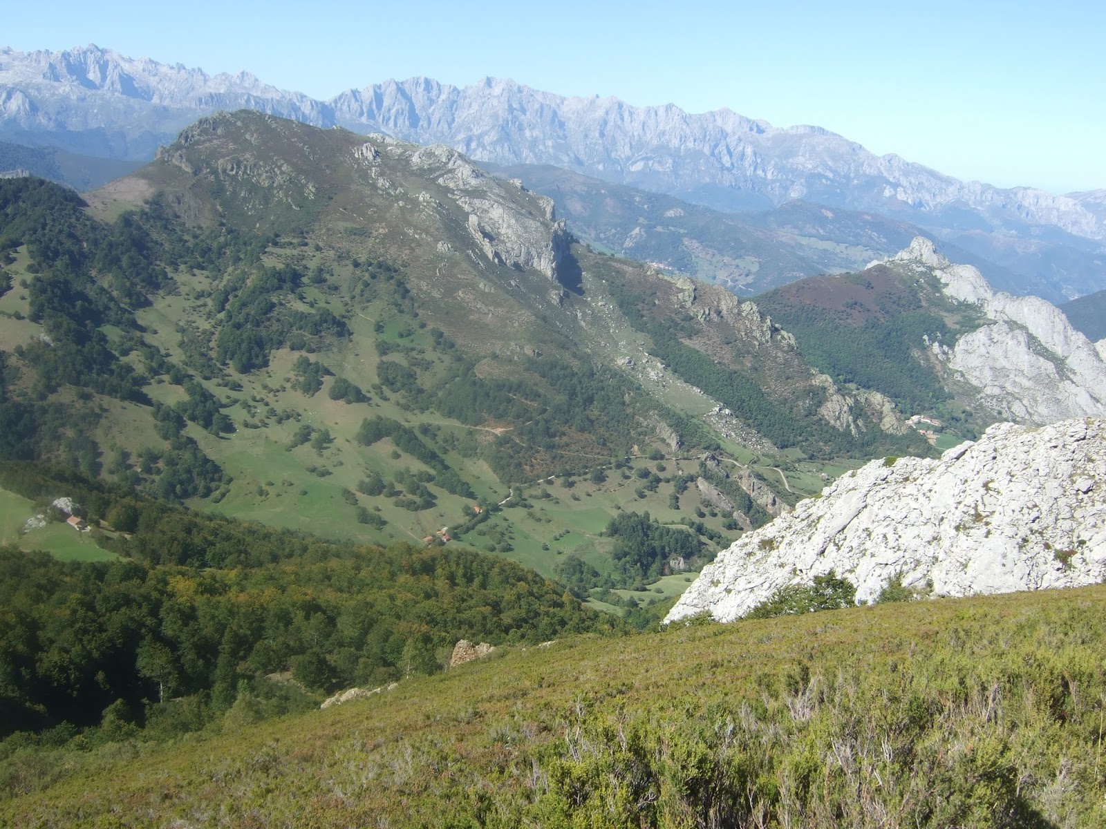
Anyway, after  a quarter of an hour or so, the mountain I'd come to climb came into view- Pico Murcia is the one on the left,  and is actually higher than the one emerging from the right - but I wouldn't see that for myself for another couple of hours.
Había salido del aparcamiento a la entrada del pueblo en dirección norte siguiendo el arroyo Lomas. A los pocos minutos una señalización a la izquierda indica una pista que pronto entra en el valle Valcabe. Al fondo del valle aparece el Pico Murcia. Al principio no tenía claro cuál de los dos era, porque él de la derecha parecía más alta. Pero engaña, como luego vería.

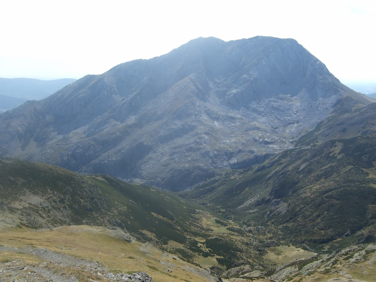
A rather beautiful mountain I think
Una montaña muy bonita, ¿verdad?

After getting to the top I planned to walk along the ridge to the left rather than coming back the same way.
Mi idea era volver por la cresta de la izq. en lugar de bajar por el mismo camino.

When I got to the grassy pasture at the fend of the valley I followed the cairns up to the right
Al llegar al final del valle una pintada en una roca (WayPoint 4) indica el sitio donde se cambia de rumbo y subes a la derecha para seguir los hitos que señalan un sendero...

and then up the slope as they guided me along a narrow path through the vegetation
... que sube la cuesta a través de la retama


The path zigzagged all the way up and I was soon well above the valley
Es una cómoda subida y rápidamente se gana altura sobre el valle

Over to the left the impressive cwm came completely into view
Hacia la izquierda un circo glaciar impresionante

meanwhile I carried on zigzagging my way up
No recuerdo un sendero con tantos zigzags 

until reaching a col just under the summit
por fin llegas a un collado al sur de la cima, que se gana con un poco más de esfuerzo

From the top there was a splendid spectacle:
To the west: Riaño and the mountains of León
Desde la cumbre unas vistas maravillosas:
Al oeste el embalse de Riaño y las montañas de León

Pico Murcia actually sits on the Palencia-León provincial limit
Pico Murcia está en el límite entre Palencia y León

The western and central massifs of the Picos de Europa
Los macizos oeste y central de los Picos

The eastern massif on the left, in the centre the mountain that from below seemed higher and on the right Peña Prieta - the highest mountain in the cordillera
A la izq. el macizo oriental, delante: el cordal que sigue hasta Peña Prieta. Ya se ve que la montaña que había visto antes desde el valle (en el centro de la foto) queda por debajo del Murcia
The Valcabe valley, which I'd come along to reach the mountain. In the foreground to the right, the end of the ridge from which I'd see the way down to the village
Debajo: el valle Valcabe. A la derecha: el final de la cresta desde donde más tarde bajaría al pueblo

Focusing more on the skyline: Curavacas, and beyond it to the left the Sierra de Cordel.
Prestando más atención a lo más lejano: Curavacas, y en el horizonte a su izq. la Sierra del Cordel. Debe de ser el Pico Lezna que impide que se vea Peña Labra

The  ridge and its highest point: El Castillo
El punto más alto de la cresta es el Pico Castillo

the majestic Espigüete
El Espigüete imponente

Another photo of the Picos
Otra de los Picos

I then walked down to Las Cerezuelas and looked back at Pico Murcia before continuing along the ridge
Después de un buen rato, bajé a Las Cerezuelas y eché un vistazo hacia atrás antes de seguir hacia el este

El Espigüete

Pico Murcia from El Castillo
Pico Murcia desde El Castillo

and from the end of the ridge
y desde el final de la cresta

while in the other direction down below, lay the village I'd set off from
Al otro lado se veía Cardaño al fondo del valle

It took me an hour to make my way down. The first part was quite enjoyable, but the last 150 metres became a bottleneck and I was lucky to find a reasonably easy way through the undergrowth. However, it could have been rather more unpleasant, and I'm not sure I'd recommend coming down this way to anyone not prepared for a bit of adventure. Anyway, I got down to the carpark at the entrance to the village and took one final look back up to El Castillo and the outcrop to the right of centre I'd started the descent from.
Tardé una hora en bajar. La primera parte era bastante divertida, pero los últimos 150 metros re convertían en un cuello de botella y costaba algo encontrar un camino entre tanta maleza. No sé si recomendaría esta bajada a alguien a quien no le apeteciese un poco de aventura. Al llegar abajo miré hacia atrás: se ve El Castillo a la izq y el punto desde donde empecé la bajada en el centro-derecha.

martes, 22 de septiembre de 2015

Entre Cantabria y Palencia / 50 up


En busca de más montañas vistas desde el Valle Estrechu me acerqué (¿me alejé?) a uno de los pueblos más altos de Liébana. Subí por el Valle de Cereceda a través de un mar de nubes para comenzar mi caminata en Cucayo.
In search of more mountains seen from afar, I made my way to one of the highest villages in the S-W of Cantabria. I had to drive up through the cloud to get to Cucayo, where I began my walk.

Sin entrar en el centro del pueblo cogí una pista que sube hacia el sur. Pasamos al lado de una indicación a los molinos de Dobres y a los 5 minutos llegamos a una bifurcación al lado de un edificio donde cogimos el ramal de la izq. que baja al río.
Taking a track that heads south, we then took a fork to the left to cross a river

Cruzamos el río Frío

A partir de ahora es toda subida, y bastante dura. Abajo quedan los Invernales de Ranes
Thereafter it was all uphill, and pretty steep too. Lovely views though, which made it all worthwhile.

Después de unos recodos llegamos a los Invernales de Praiza - se ve el Pico Paraes al fondo
The track zigzags a bit and comes out here

Después de pasar delante de una cabaña a la derecha, junta a una pista que baja a Ranes, entramos en una zona arbolada. Un poco después, en una curva donde hay una verja a la izq. no debemos seguir el camino de frente sino seguir la pista hacia arriba a la derecha.
There was the occasional brief incursion into the woods but the walk was mainly through pasturelands

El Bistruey y Pico Córcina hacia nuestra izquierda
I walked up those two just a month ago


Peña Prieta y a la izq. Peña Quebrada

Llegamos a la base de Pico Pumar y dejamos por fin la pista, que muere pronto después, para subir la cuesta hacia el collado a la izq. de la cima
Eventually we reached the foot of Pico Pumar and left the track to make our way up the hill to the left of the summit

 Se hace duro la verdad. Cuando llegas arriba aparece por primera vez el Pico Lezna, pero primero a seguir un poco hacia la derecha a coronar el Pumar, que está en la divisoria entre Cantabria y Palencia
Hard going it was too. Pico Lezna comes into view for the first time, but before that we headed up right to get to the top of Pumar, which is right on the border between Cantabria and Palencia.

Desde la cima mirando hacia la zona de donde vinimos.
Looking down towards the area we came up from.


Donde estuvimos hace pocas semanas: El Bistruey y Pico Córcina, con Peña Sagra y el Valle Estrechu al fondo
Bistruey and Pico Córcina in the foreground; on the horizon the Peña Sagra sierra, from where I had looked across at these mountains and located them on a map, setting today's adventure in motion.

Después de una corta parada seguimos hacia el sur hasta llegar a la cumbre de Pico Lezna, ya en Palencia
We then continued into Palencia and made our way up to Pico Lezna


Sobrecoge la vista de Curavacas justo en frente
From the summit the imposing sight of Curavacas just opposite really stands out

Peña Prieta a la derecha. ¿Puede ser Pico Murcia al fondo a la izquierda?


Pico Pumar a la izq.  el Bistruey a la derecha
The walk up from Pico Pumar

La Concilla, Peña Labra y Alto Campoo

El Río Carrión corre entre Lezna y Curavacas
Thr Carrión River runs between the two mountains


Los Picos de Europa desde la cima de Pico Lezna
The typical letterbox on the summit, with the Picos to the north

No corría mucho aire y la gran cantidad de moscas me llevaron a buscar otro sitio para parar a comer. Después tocaba bajar por el mismo camino, bordeando el Pumar y atravesando el brezo para coger la pista.
There was hardly any wind, and lots of flies, so I had to look elsewhere for a place to sit and have something to eat. And then the walk back down, past the Pumar and down through the heather to get back onto the track.

Abajo se ven Los Invernales de Ranes

Otra del Bistruey, ahora que el sol no molestaba

En este cruce al lado de la cabaña se sigue de frente. En este sitio en la subida tuve que andar con cuidad por los dos mastines que guardan las ovejas - por suerte, Monty no les parecía causar demasiada preocupación
As we went past this hut I had to tread gingerly, as there were two mastiffs with the sheep and they'd made it clear Monty wasn't welcome on the way up - second time around they weren't so threatening.

Antes de llegar a Cucayo salí del camino unos minutos para echar un vistazo a los dos molinos, que datan del siglo XV. A estas alturas Monty iba bastante molido por cierto - espero que sólo sea por la temperatura.
Just before arriving back in Cucayo we left the track a few minutes to go and see two 15th century watermills.

Ya en casa vi que según mis cuentas el Pico Lezna es el dosmil número 50 que he subido.
Back home, I saw that according to my calculations Pico Lezna made it 50 mountains I've been up standing at over 2000 metros (6562 feet).