miércoles, 27 de septiembre de 2017

Valdominguero (2)


Uno de los caminos hechos por los mineros de otros tiempos nos lleva hacia el Pico Valdominguero
Using one of the tracks built by miners long ago we make our way to Pico Valdominguero

Es ese que se ve al fondo en el centro. En primer plano las ruinas de una caseta de las minas de Mazarrasa
It's the peak in the centre of the photo. In the foreground the ruins of a hut at the Mazarrasa mines

Detrás del Mancondíu se veía el mar y la playa de Merón, cerca de San Vicente
We came up past this mountain. Behind it the sea and the beaches near San Vicente can be seen 


Al llegar al collado de Valdominguero avistamos la canal de Fresnedal enfrente, culminando en Peña Castil (izq.), y a nuestros pies la canal de Jidiellu (derecha)
When we got to the Valdominguero pass we found ourselves right opposite the Fresnedal valley, leading up to Peña Castil (left), while at our feet is the Jidiellu valley, coming up to this point


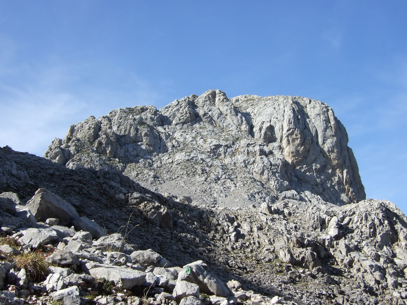
A nuestra derecha el Pico
On our right is Pico Valdominguero

Lo rodeamos para subir hasta la cima desde el este por una grieta en la roca que se sube bien usando a la pared a la derecha como apoyo. Yo temía que en la bajada iba a pasarlo mal debido a mi acrofobia, pero felizmente no fue así
We walked round the base a little to make our way up to the top from the east via this cleft in the rock. I was a bit worried I'd suffer on the way down, but in the end it was pretty straightforward.

Mirando hacia atrás desde el mismo lugar
Looking back down from the same spot


Casi en la cima, se ve la parte recién ascendida hacia la derecha, y abajo el collado
Near the summit, you can see the part of the climb just covered to the right, with the pass down below


Ya en la cima se ve el camino que seguimos bordeando los hoyos para llegar hasta aquí. Detrás están varias cumbres del macizo oriental: el Samelar, San Carlos (se asoma un poquito), la Junciana y más cerca la Rasa, con su cima herbosa
From the summit you can make out the path we took along the side of the depressions. Behind are various mountains in this eastern massif of the Picos de Europa


Hacia el sur está la Pica del Jierru y a su derecha los Campos de Valdominguero, que visitaríamos más tarde. Detrás de éstas se alza el Pico Cortés
To the south is Pica del Jierru, and Pico Cortés behind to the right. In front of this mountain are the Campos de Valdominguero, which we would explore later


Espectacular la vista al macizo central; los picos del horizonte desde Peña Vieja a la izquierda, pasando entre otros por Santa Ana, Tiros Navarro, Horcados Rojos, y más adelante el Urriellu y Peña Castil con los Picos de Albo a la derecha de la foto.
This spectacular view is of the Central Massif.

Hacia el norte la Sierra de Cuera
To the north lies the Sierra de Cuera

Después de almorzar en el collado subimos enfrente a los Campos de Valdominguero. Así se ve el Pico recién ascendido desde allí, con Mancondíu atrás en el centro-derecha
After having something to eat at the pass we walked up to the Campos de Valdominguero opposite. From there we looked back at the Pico Valdominguero. Mancondíu is behind  (centre-right)

Mirando en dirección opuesta:
En el centro de la imagen el Escamellau, con Áliva debajo y la pista que recorre la Llomba del Toro
Meanwhile, in the opposite direction:
In the foreground is Escamellau, with Áliva at its feet


Hacia el sur: el Pico Cortés
To the south Pico Cortés

Pica del Jierru a la izq. y Morra de Lechugales atrás a la derecha
More mountains: Pica del Jierru (left) and Morra de Lechugales (behind on the right)


Otra imagen de la Pica del Jierru, donde se ve la brecha en la roca por donde se accede a la subida a la cima desde la pedrera que cae hacia el lado izquierdo
Another view of Pica del Jierru. To get to the top you walk up the scree slope towards the right, then go left up a short steep gulley that can be seen to the right of the photo, then the rest of the walk up to the summit is straightforward


Bajando al collado de Valdominguero estos dos rebecos se vieron obligados a apartarse de nuestro camino
Coming down to the pass we watched these two ibex calmly amble out of our way

Emprendimos la vuelta. El lado del Pico Valdominguero por donde subimos en diagonal
We went back the way we'd come. The side of Pico Valdominguero we walked up diagonally to the left

Ya acercándonos al Jito de Escarandi disfrutamos de una nota de color distinto: las hayas que que empiezan a cambiar de color con la bajada de temperatura otoñal
Nearing Jito de Escarandi we were treated to the first signs of autumn: the beech trees starting to change colour now the temperatures are dropping


Para más fotos y explicación del camino a Valdominguero ir a otra entrada de hace tres años:
For more photos and description of the walk to Valdominguero go to another entry from three years ago:

viernes, 15 de septiembre de 2017

Castro Valnera en famille


Perfect weather but not enough time for a long walk. Destination: Lunada Pass, the provincial limit between (South East) Cantabria and Burgos. From there a path runs to the SW, giving views of the Picones de Sopeña, as well as the road we'd driven up to get here.
Un día perfecto para andar por el monte, pero no disponíamos de mucho tiempo, así que decidí ir al Portillo de Lunada para que mis familiares ingleses hicieran una excursión clásica. Desde Lunada una senda se dirige hacia el suroeste, y en seguida tenemos vistas sobre los Picones de Sopeña.

A little to the left. Beech trees contrast with the emptiness of the rest of the hillside, which was shorn of its trees in the 18th century.
Hacia la izquierda un hayedo contrasta con el resto del monte alrededor, que estaba cubierto de árboles hasta que  empezaron a talarlos en el siglo 18

The first climb was up to Pico la Miel
La primera subida es al Pico la Miel


Castro Valnera from Pico la Miel
Desde allí vemos Castro Valnera

Porracolina and La Colina in the distance
A lo lejos Porracolina y la Colina

Descending the steep slope to the south of Pico la Miel
Descendiendo la cuesta empinada al sur de Pico la Miel

Last time I was here I approached from El Bernacho, on the Burgos side, following the track through the valley below us.
La última vez que andaba por aquí, me acerqué desde el Bernacho en el lado burgalesa, siguiendo la pista por el valle que vemos abajo.


After descending to the collado de la Pirula, we went up again to the SW. The last few yards up to the summit of Castro Valnera
Después de descender al collado de la Pirula, volvimos a subir hacia el suroeste. Aquí se ven los últimos metros para llegar a la cima de Castro Valnera.

Nephews and Sister at the summit
Sobrinos y hermana en la cima

Looking down into the valley to the west
Mirando el valle hacia el oeste

Matthew and I continued to the Alto Los Dojos, from where we looked back at Sarah and James
Matthew y yo seguimos hasta el Alto los Dojos, desde donde veíamos a Sarah y a James

The steep walk up I intend to take next time I come up here
El "kilómetro vertical", que será por donde pretendo subir la próxima vez que vengo por aquí

La Cubada Grande to the SE
Hacia el SE, La Cubada Grande

Pico La Capía with Peña del Cuervo just behind with a sheer drop to the right
Pico la Capía, con Peña del Cuervo justo detrás.

 Castro Valnera from the foot of Los Dojos
 Volviendo de Los Dojos así se ve Castro Valnera

Just as we set off on our way back a cloud appeared from the valley below and changed the temperature and visibility completely
Nada más empezar la vuelta una nube apareció del valle y se cambiaron tanto la temperatura como la visibilidad


But all bad things come to an end, and we made our way back up from the collado la Pirula. Pico la Miel just ahead along the ridge to the left.
Pero ya se había difuminado para cuando llegamos a la cresta de enfrente. Pico la Miel está a la izquierda.

Looking back, the summit of Castro Valnera can be seen behind and just to the left of the mountain ridge.
Hacia atrás, la cima de Castro Valnera se ve detrás y justo a la izquierda de la espina dorsal de la montaña.


lunes, 4 de septiembre de 2017

Hoyo Sin Tierra


Por tercera vez este verano subí por el teleférico para hacer una ruta por el macizo central.
I took the cable car up from Fuente Dé for the third time this summer.

Nos desviamos al llegar a la Vueltona para coger una pista hecha por las compañías de minas hace decadas. Se ven la Padiorna, Altaiz y San Carlos (objetivos de mi última salida por estos lares), y a la derecha la Torre del Hoyo Oscuro y Madejuno.
At the Vueltona (2.000 mts) we left the main track up to the Cabaña Verónica refuge and turned left. As we came round the bend, Torre Altaiz and Pico de San Carlos (see last trip to Picos) were straight ahead.


Poco después llegamos al Collado de Fuente Escondida. Delante está el Hoyo Sin Tierra, y al otro lado la Torre de Horcados Rojos con el Tesorero a la izquierda. Aquí cambiamos de dirección, y seguimos un sendero hacia el norte bordeando el hoyo.
Shortly afterwards at the Collado de Fuente Escondida. In front of us is the Hoyo Sin Tierra depression, with Torre de Horcados Rojos on the other side. Here we changed direction, following a path northwards around the depression.


Una mirada hacia atrás. Se aprecia el sendero que hemos cogido a la base de Torre Altaiz
A look back. You can make out the path taken at the foot of Torre Altaiz.


Enfrente vemos la horcada de Casares, entre la Torre del Hoyo Oscuro y el Madejuno (en la imagen)
Opposite is Tiro de Casares between the two mountains to the right of San Carlos.

Mirando hacia los picos de Santa Ana y Peña Vieja
Looking towards Santa Ana's two summits and Peña Vieja

Hemos subido lo suficiente para poder ver Cabaña Verónica, al pie de Horcados Rojos
We've now ascended enough for Cabaña Verónica to become visible at the foot of Horcados Rojos

A partir de ahora subimos y bajamos por las rocas siguiendo los jitos
From now on we make our way from cairn to cairn through the rocky terrain

En el centro de la foto está Torre Blanca
In the centre is Torre Blanca, the highest point in Cantabria

Qué suerte hemos tenido con el tiempo. A medida que rodeamos el Hoyo disfrutamos de perspectivas cambiantes de los mismos protagonistas.
We were really lucky with the weather. As we went round the Hoyo Sin Tierra we saw the same protagonists from constantly changing angles.

Torre Altaiz y San Carlos a la izquierda de la Torre del Hoyo Oscuro
Torre Altaiz and San Carlos on the left and Torre del Hoyo Oscuro up to the right

Un paso un poco aéreo antes de llegar a Cabaña Verónica. ¡Menos mal que no había viento!
A narrow ridge on the way to Cabaña Verónica - luckily it wasn't a windy day

El refugio de Cabaña Verónica
The distinctive (small) Cabaña Verónica refuge

Horcados Rojos y la Torre del mismo nombre. Por aquí nos asomamos desde el otro lado hace mes y medio.
Horcados Rojos and the mountain that shares the name. We came up to that point from the other side  just a few weeks ago.

El lugar donde nos pusimos a almorzar (y algunos a sestear). Detrás se levanta el Tesorero.
This is where we stopped for a bite to eat (and a siesta in some cases!) The mountain behind is Tesorero

El paso aéreo que comenté antes desde cerca de Cabaña Verónica.
The ridge we crossed earlier from near Cabaña Verónica

Un momento durante la bajada al cable por el camino habitual
On the way down to the cable car via the usual route

Por la mañana habíamos pasado por debajo de esos dos picos de enfrente.
During the morning we'd been right beneath those two mountains over yonder

Una ruta estupenda en la montaña, y además llegué a casa con tiempo para disfrutar de la compañía de mis sobrinas. Un día redondo.
All in all, a lovely day in the mountains.