
More photos taken on the way to San Esteban


The village comes into sight, an hour after I set off, with the Ciercos Valley to the right, which I explored in 2009


An unusual sight: a dead chestnut tree with a commemorative plaque in recognition of the sustenance its fruit gave over 400 years to the locals

At last the "Pasá del Picayo" walk was underway, and San Esteban below


After an initial ascent up through woodland with mainly leafless trees I reached a point where I had to change direction


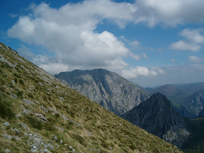
The route skirts the Cocón Sierra and ascends giving views of the mountains above the Ciercos Valley...

...as it winds its way round the rocks


This is the Cabeza Vigueras, which I last climbed in 2010 - see the first entry on this blog


This was the steepest section of the walk

Another mountain I climbed some time ago comes into view, to the right of Cabeza Vigueras


The Ciercos Valley again


Eventually the route reaches a point where it overlooks the Gorge and gradually changes direction


This is the view up the Gorge towards Urdón


and from a bit farther on

The Cueto del Ave (see June 2010) was audible almost before I could see it owing to the water crashing down from the hydroelectric plant

Another view of the Gorge below, at the point where I left the main road earlier on


You can see the Canal de las Aileras on the Cueto clearly here. Until I saw the scree I found it hard to believe this was the walk I did a year ago as it seemed so steep from across the way.


As the path continued round the side of the Sierra, the Picos de Europa came into sight


Another mountain I visited some time ago, on the left, just above the village of Bejes


The Cueto del Ave again

Imagine losing your balance and slipping down that scree and over the edge...


At last Tresviso came into sight, with the Picos behind, from Samelar to the Naranjo - minutes before they were covered in cloud, as I sat and had my lunch


A look back

And Tresviso just ahead.

On the way down from Tresviso now, another angle of the Jontaniella, above Bejes, and the collado Pelea, which leads to Potes

The first part of the descent from Tresviso


The path zigzags spectacularly

Right opposite the hydroelectric plant now


The river Urdón

a shot of the path

the final part of the descent as it snakes its way down the mountain


looking up the scree in the Canal la Cerrosa


and from a bit further down

Eventually you get to the point where the torrents of water crashing down the Cueto del Ave reach the Urdón

Looking back up the river everything's placid


but the other side there's a tremendous roar as the cascade joins the river


Looking up towards the initial release of water

And finally the end of the walk, with a photo of the entrance to the Urdón valley


and the main road along the Gorge as it goes into Asturias, which I started walking along seven hours earlier


