sábado, 18 de julio de 2020

El Río Dobra bajo las nubes/Eyes down


Tenía en mi lista desde mucho tiempo la senda que bordea el río Dobra, afluente de Sella. En Amieva, donde dejé el coche, se veían muchas nubes bajas. No se levantaron en todo el día pero aun así pude disfrutar de las vistas del valle por donde discurre el río.
Taking advantage of the low temperatures forecast I got up early to do a long walk in Asturias. The clouds didn't lift at all, but as the walk followed a river there were lovely views to be had even if the mountains were hidden from view.


Hórreo-Amieva

Por una pista que sale a la derecha desde la entrada al pueblo subí andando hasta el Cueto de Angón, aunque se puede subir en coche, ya que hay un pequeño aparcamiento en el collado. La ruta (PR-PNPE-7) está balizada, y continúa con una bajada hacia las casas que se ven al fondo.
I parked in Amieva and then walked up a narrow road to the right at the entrance to the village. There is a small carpark at the collado de Angón for those who wish to make the hike shorter; from that point the track carries straight on,  heading down towards the two houses in the photo
Valle de Angón
Pasé al lado de la central eléctrica de Restaño y obtuve la primera vista del Dobra, rodeado por una vegetación exuberante
I passed the Restaño power station and saw the river Dobra for the first time, surrounded by exhuberant vegetation


Se cruza el río y comienza una subida a través del bosque. Una mirada atrás:
I crossd the river and walked up through the woods. A look back at the valley:

Se llega a Bellanzo
The climb levels off at Bellanzo

Cerca está la Presa de la Jocica. Merece la pena leer la información en un panel sobre la construcción de la misma. Un poco más adelante vi una placa en memoria de un joven que fallecía en 1948 - me preguntaba si tendría que ver con las obras...
Nearby is the Jocica dam

Y a partir de ahí seguí la Senda de la Jocica, que sube por la margen derecha del río, manteniéndose a una distancia constante sobre el mismo
The continuation is named the Jocica path, which makes its way up the right-hand side of the river
Embalse de la Jocica


Atraviesa zonas muy bonitas
It passes through very pretty spots


Antes había visto un escribano cerillo por primera vez en muchos años, pero aunque no conseguí una buena foto del pájaro,  por lo menos esta mariposa fritillaria se quedó quieta.
Earlier on in the walk I'd seen a yellowhammer for the first time in years, but was unable to get a decent photo - this fritillary stayed still long enough though.

Por fin se llega a Carombo. Para no volver por el mismo sitio había decidido cruzar el río y conectar con otro camino. Desde la cabaña de la foto bajé al río, por una senda no siempre fácil de seguir pero que va con tendencia hacia la izquierda. Me despistó un poco ver una señalización a Barcinera /Vegabaño que estaba al revés, pero el camino al puente sobre el río es evidente
Eventually you get to Carambo. Rather than returning the way I'd come, I'd decided to cross the river and link up with another path. From the hut in the photo I walked down to the river; the path isn't all that clear, and it's advisable to keep to the left when in doubt. I ignored a confusing signpost which seemed to be facing the wrong way and followed the obvious path to the bridge over the river

El Dobra
Al otro lado se atraviesa un helechal y comienza una subida de unos 250 metros durilla pero por zonas muy bonitas
On the other side the path was just about visible through the fern, but then leads uphill very clearly through pleasant woodland


En el Puerto de la Barcinera hay un cruce. A la izquierda se va al refugio de Vegabaño, pero yo seguí a la derecha siguiendo la señalización Soto/Beza. Esto ya es territorio leonés.
At the top of the hill (Puerto de la Barcinera) there's a crossroads. The left-hand path leads to the Vegabaño refuge, but I took the one to the right (signposted Soto/Beza). We are now in the province of León.

Aquí paré a comer. Ya llevaba casi 5 horas caminando. Esta mariposa llamada montañesa ojitos se colocó delante de mí y ya no se movió. Lo menos que podía hacer era inmortalizarla en mi blog
This mountain ringlet butterfly flew down in front of me while I sat for a bite to eat and didn't move thereafter. The least I could do was include it in my blog

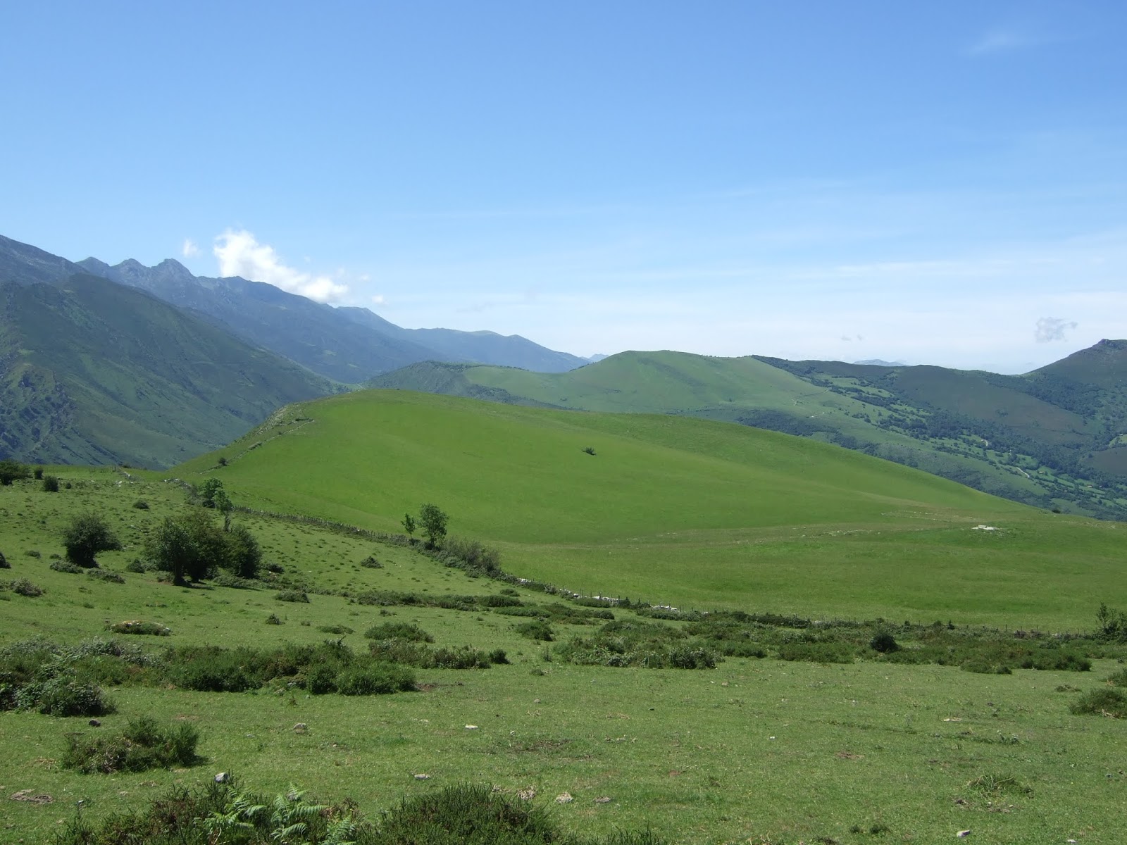
Poco después hay una bifurcación. El camino de la izquierda baja a Soto de Sajambre y el sendero que cogí sube a la derecha hacia el Portillo de Beza. Queda unos 200 metros de subida suave que ofrece vistas bonitas hacia el sur. Ahora estamos en la provincia de León
Soon afterwards there's a fork in the track. The left-hand path goes down to Soto de Sajambre, but I took the one to the right (signposted Portilla de Beza) that goes uphill through lovely countryside offering views to the south.

Soto de Sajambre
Paso al lado de la Peña Beza, que se deja ver momentáneamente
I walked round the foot of Beza, which was briefly visible through the cloud

Me parecía un sendero precioso
From the fork you go up 200 metres

Llegamos al Puerto de Beza, donde hay un abrevadero. No hay que ir más abajo que éste, sino mantener la misma dirección que traíamos y subir ligeramente hasta llegar a la Portilla de Beza. El nombre me había confundido un poco, porque en los mapas que traía, este sitio se denomina Portilla (o Cruz) de Tarabica, pero evidentemente es el mismo lugar, el punto más alto de la ruta (1.500m) y lo confirmaban los restos de un panel informativo sobre la Senda del Arcediano. Esto es el final de la PR-PNPE 7, pero sigue la GR-201. También es donde pasamos otra vez a Asturias.
We get to the Beza pastures, where there's a drinking trough. It's important not to follow the path leading down from here, but keep the same direction as before and go up a bit till you get to a gate in a stone wall. This is the Portillo de Beza, which marks the end of the signposted route followed thus far, though the GR-201 continues from here. We also leave León at this point and re-enter Asturias, as well as connecting up with the Senda del Arcediano, a historic pathway.
Puerto de Beza

Por desgracia, la nube ya me impedía disfrutar de más vistas que las inmediatas. Me acuerdo de cuando hice la Senda de Arcediano ¡hace más de 30 años! que eran soberbias. En aquella ocasión fuimos de Amieva a Soto.
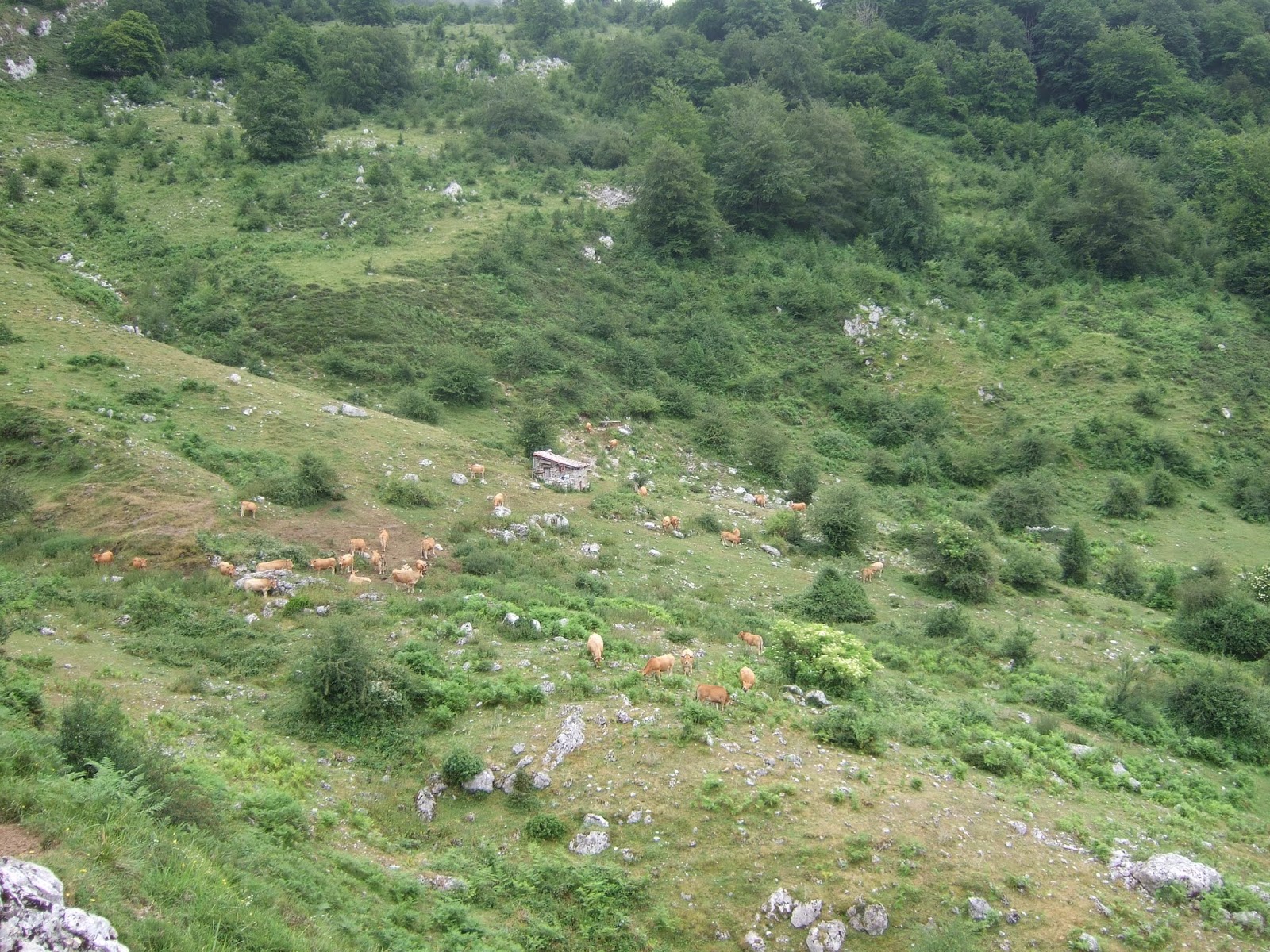
Bajando con tendencia a la izquierda se llega a la majada de Toneyu
I remember having done this walk in the other direction over 30 years ago and enjoying lovely views,  but not today; low-lying cloud made it impossible to see anything any distance away.
We now go downhill towards the left and go past Toneyu

El sendero no estaba claro en esta zona y en estas condiciones, así que me venía bien seguir un track que había descargado, y me alegré de pasar al lado de esta señalización, porque coincidía con una parte de la senda más evidente y fácil de seguir.
As the path isn't very clear here I needed to use the trail I'd previously downloaded, but all the same was relieved to see this sign, which coincided with the cobbled path becoming easier to follow.


Aunque no veía las cumbres, reconocía el valle de Angón hacia la derecha, por donde había pasado esa mañana
Although I couldn't see the peaks, I recognised the Angón valley I'd been through that morning over to the right

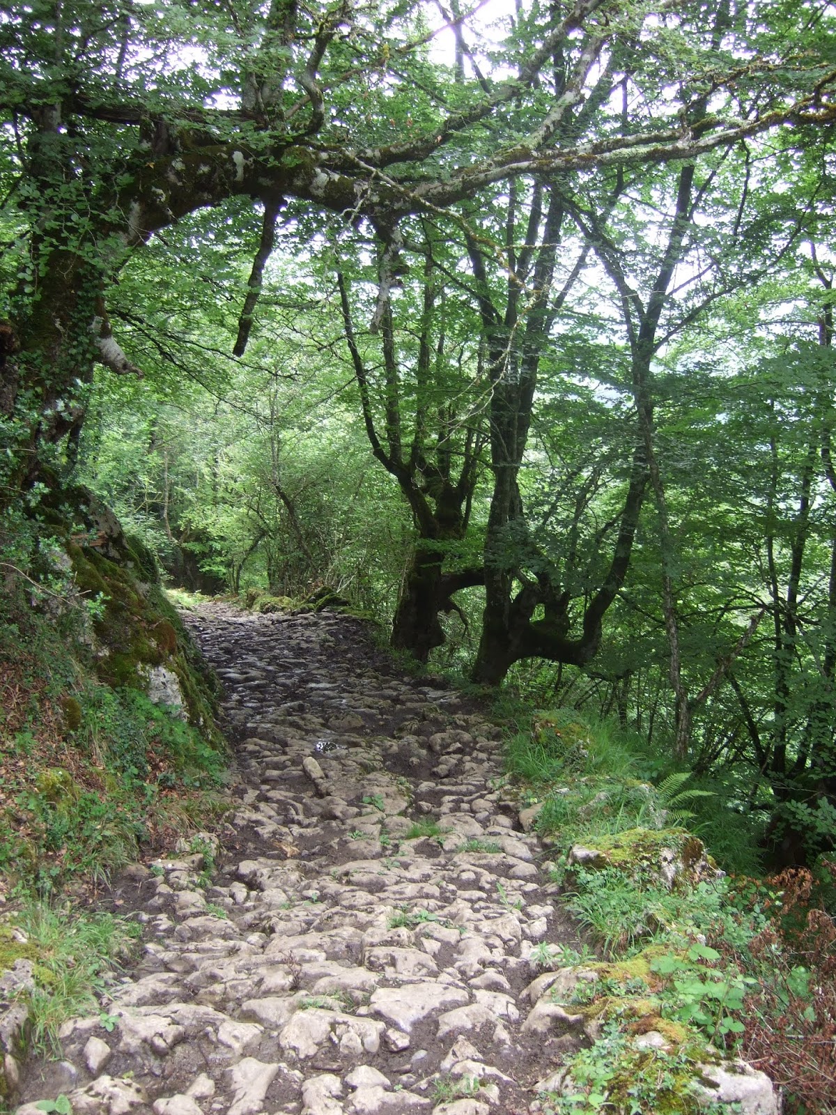
La última parte de la Senda es muy bonita, aunque en las zonas donde está mojada hay que ir con mucho cuidado
The last section of the path is particularly eye-catching, though you have to tread carefully where the cobblestones are wet


Al llegar al aparcamiento del collado de Angón me descuidé y casi me resbalo allí mismo. Me quedaba unos 40 minutos bajando por la carretera a Amieva. La nube se mantenía inamovible.
When I reached Angón, I relaxed and almost took a tumble right on the slope down to the carpark. Thereafter I had a 40-minute walk down the road I'd walked up that morning. The cloud was definitely staying put.

Aquí dejo un enlace al mapa de la ruta. Tardé 9 horas y media. Está claro que habría sido una excursión más bonita sin la nube baja, pero ¡por lo menos no pasé calor!
Here is a link to a map of the route I followed. I took 9 and a half hours. It would obviously have been a more spectacular hike without the cloud cover but there again, it would probably have been uncomfortably warm!

https://www.miteco.gob.es/es/red-parques-nacionales/nuestros-parques/picos-europa/ruta_pr_07_tcm30-70914.pdf


lunes, 6 de julio de 2020

En torno a Tudanca / a walk with literary links


No había pisado Tudanca en 25 años, desde de que hicimos el GR 71 al llegar a Cantabria. Pero después de releer "Peñas Arriba" sentí el interés en recorrer los sitios que inspiraron a Pereda cuando escribió su novela. A finales del siglo XIX se llegaba a Tudanca (la Tablanca de la novela) por el Camino Real. Este sería la primera parte de mi ruta. Dejé el coche en el aparcamiento y subí hacia el pueblo. Siguiendo las indicaciones a la izquierda caminé por la margen derecha del Nansa durante casi hora y media. El camino estaba encharcado en algunas zonas pero resultó ser un paseo muy agradable.    
I hadn't been to Tudanca since we did the Saja Reserve walk 25 years ago, just after coming to live in Cantabria. Having re-read a novel set in the village I decided to visit the area. Walking up from the carpark at the bottom of Tudanca I soon came to a signpost to the left for the Camino Real - the old route that linked the villages on the river Nansa. It's a pleasant walk though muddy in places, but the shade was welcome.

Se ve el río de vez en cuando
You occasionally get to see the river

La mayor parte del trayecto estaba en sombra. Cerca del final del camino hay que vadear un arroyo. Hay un primitivo puente a la izquierda que no vi hasta que había franqueado la valla - demasiado pendiente de la ladera que veía arriba hacia la derecha supongo
Near the end of this part of the route you have to cross a stream. There's a makeshift wooden bridge on the left that I didn't see till I'd gone under the fence - I suppose I had my eyes on the slope that awaited me


Al llegar a la altura del puente de Sarceda cambié de dirección. Una pista sube a la derecha (S) en un giro abrupto. Pero primero decidí continuar 200 metros en ligera bajada para ver como seguía el Camino Real:
A track leads off sharply up to the right (S). Before taking it I carried on down 200 yards to see the lie of the land

La subida se hacía cómoda a pesar de la temperatura estival ya que hay frecuentes zonas de sombra.
The track uphill had plenty of shady areas so I didn't suffer from the summer temperatures

Algo después de cruzar un riachuelo,  cerca de un cruce con un camino que sube hacia el norte (para morir pronto según el mapa), la pista se convierte en senda. Primero probé la senda y pronto llegué a esta bifurcación.
Not long after crossing a stream, near where a grassy track leads off to the north, the track I was on becomes a narrow path. I carried along the path and soon came to this fork

El camino de la derecha llega a este lugar, pero a partir de ahí, al cruzar la Canal de Aras no vi sendero así que volví al cruce con el camino herboso que sube al norte 
The right-hand one leads to this spot, but the path peters out shortly afterwards on the other side of a gully, so I turned back to try out the grassy track 

El camino llega pronto a esta cabaña en ruinas. De allí cogí un sendero en desuso hacia el SE antes de acometer el resto de la subida monte a través
It goes up to this hut abandoned years ago. From there I took a path to the SE before heading straight up the hillside

La aulaga y demás vegetación, junto con la pendiente convertía la empresa en una de esas situaciones en que te alegras de no ir acompañado, ¡así no tienes que rendir cuentas por haber llevado a los acompañantes a un lugar tan incómodo!
The gorse and other vegetation, together with the slope made me feel relieved I was on my own as otherwise I'd have felt guilty about leading man, woman (or dog) into such an uncomfortable environment!

En las frecuentes paradas miraba hacia atrás y disfrutaba de la vista de la Sierra de Peña Sagra
On the many stops as I made my way up I looked back and enjoyed the view of Peña Sagra

Hacia el sur Cueto de la Concilla, Tresmares, Peña Labra... Más cerca se ve el Prau Conceju de Tudanca, por donde luego bajaré
Looking southwards familiar mountains came into view. Nearer is the meadow above Tudanca I'd be going past later on

Casi en la cresta, que divide los valles de Tudanca y Cabuérniga
Almost up to the ridge, which lies between the Tudanca and Cabuérniga valleys

Sentí alivio al llegar arriba, echando una mirada atrás a la ladera que había subido. Al fondo se ven los Picos de Ozalba
I felt relieved once I got to the top, casting a look back at the hillside I'd walked up.

Se ve claramente la pista que sube desde La Lastra al collado Abellán
The track up to the Abellán col opposite Tudanca is clear to see

y la cresta que voy a seguir hacia el sur. Aunque ya no había subida fuerte me esperaba algo peor: las picaduras continuas de los tábanos que había en la braña
The ridge I was now to walk along. No more steep slopes, but something worse awaited me: constant horsefly bites as I made my way southwards

Por lo menos encontré un sitio donde podía almorzar en paz. Hacia el este está Castro Valnera en el horizonte, y Sobrecomillas y Tambuey a la derecha de la foto
At least I found a place where I could have my lunch in peace. The photo shows the view to the east

Detrás del precioso Prau Conceju veo Curavacas, el Bistruey, Peña Prieta al fondo y más cerca el Cueto Cucón
The beautiful communal meadow of Tudanca

Llego a Caorra, el punto más alto del día y por fin he dejado los tábanos atrás. Es momento de disfrutar del verdor que me rodea: hacia el norte, la cresta recorrida
On reaching Caorra, the highest point of the walk I'd left the insects behind. Time to enjoy the green countryside around me: to the north, the ridge I'd just walked along

al este la Canal de Valfría
eastwards


Ahora bajo al oeste para conectar con la pista que rodea el bello tapiz que es el Prau Conceju
Now I headed down to the west and joined the track that goes round the beautiful meadow

Más tarde veo Tudanca abajo
Later Tudanca came into view below me

y llegando, veo la Casona, con sus paredes blancas en la parte alta del pueblo. Pereda se inspiraba en este edificio del siglo XVIII al escribir Peñas Arriba
and on arriving, I see the Casona (the Big House), with its white walls in the upper part of the village. This building, from the 18th century, features strongly in the novel I read

En la vida real, la Casona ha servido de lugar de encuentro de muchos escritores claves de la literatura española de la primera parte del siglo XX como Unamuno, Miguel Hernández, Alberti y Lorca. Ahora es un museo que merece una visita. En la pared se ve una basna, utensilio con que los lugareños bajaban la hierba segada desde el Prao Concejo
In real life the house was a place where many renowned Spanish writers from the early twentieth century gathered, and is now a museum. On the wall is a kind of sledge used by the locals to bring the hay down from the meadow in years gone by.

La fachada norte de la Casona
The northern face of the Casona