martes, 19 de febrero de 2019

Peña Redonda


Peña Redonda me llamó la atención cuando andábamos por Palencia con José Manuel y Manoli en 2015. Es una mole de casi 2000 metros coronada por una cruz que se ve desde lejos. En esta foto sacada en Pico Las Cruces en la Sierra del Brezo está al fondo hacia la derecha
I first noticed Peña Redonda when we were staying in Palencia with friends from Seville. A mass of rock almost 2000 metres high, it's crowned by a metal cross that can be seen from quite a distance, though in this photo taken from elsewhere in the Sierra del Brezo what struck me was the solid presence of the mountain away to the right.

Desde el pueblo de Villanueva de la Peña caminamos desde el SSO hacia Peña Redonda
We set off from the village of Villanueva de la Peña, which lies to the SSW of the mountain

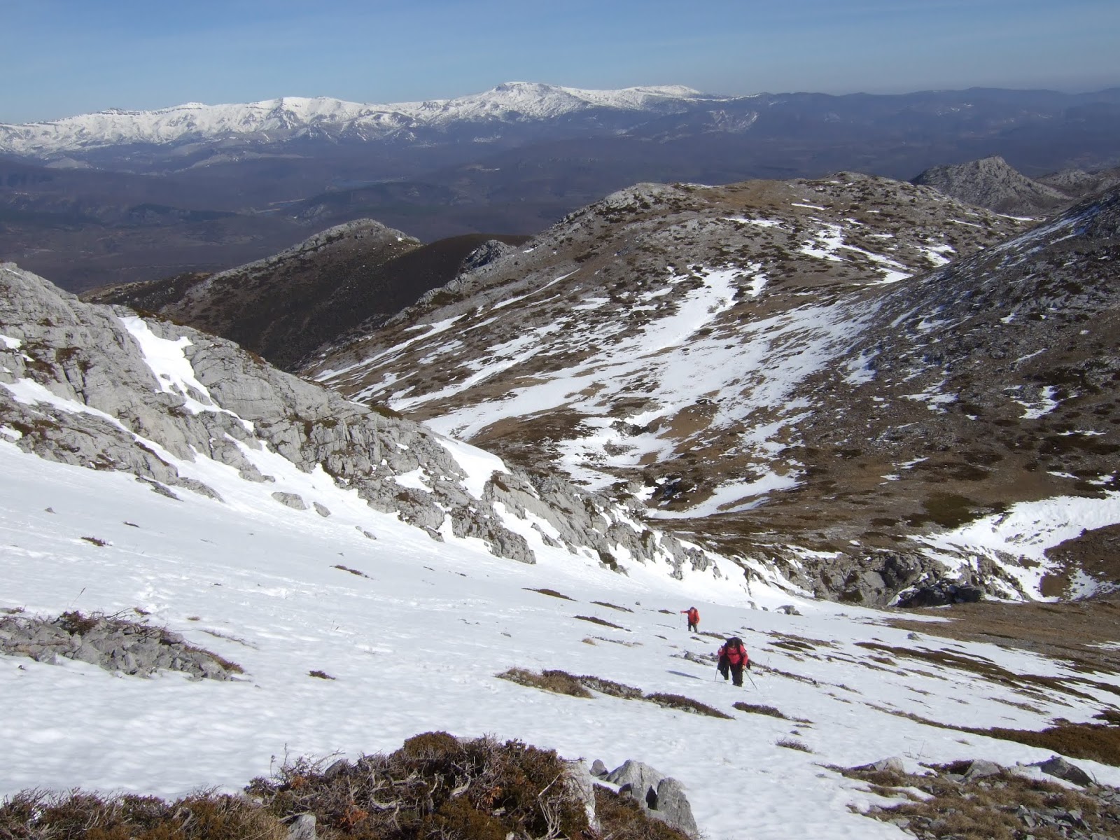
Siguiendo caminos de cabras subimos directamente para luego buscar algún camino que nos llevara en diagonal hacia la derecha
Following goat paths we headed straight up the side, before looking for one that would take us to the right

Al llegar a la zona de arbustos y matorral subimos más y luego bordeamos la zona escarpada de rocas yendo hacia el este, a veces teniendo que perder altitud. Los árboles de la foto están muy cerca
del punto donde se puede cambiar de dirección
The presence of bushes and scrub led us to keep going up in the hope of finding a path heading east. This didn't really appear, so when the steep rockface prevented us from making further progress uphill we had to make our way to the right as best we could, following whatever paths we came across and even going back downhill at times. By the time we got to the trees in the next photo though we were on the verge of being able to change direction


Al dejar los acantilados a nuestra izquierda pudimos avanzar hacia el norte, pronto enlazando con una senda que viene de Traspeña de la Peña
The steep cliffs on our left gave way to easier terrain and we were able to head up to the north, soon getting onto the path that comes up from another village


Subimos por la senda hacia un collado entre el Pico de Burrián a la derecha y Peña Redonda a la izquierda
We followed the path up to a col with Peña Redonda to the left


Desde allí vemos las cumbres de Peña Labra, Peña Sagra y Peña Ciquera hacia el norte
From there we caught our first glimpse of the mountains to the north

Nos quedan 300 metros de subida empinada a nuestra izquierda
The final part of the ascent was the steepest


La cruz metálica que llama la atención desde lejos quita belleza cuando se llega a la cresta cimera
The metal cross that is noticeable from afar detracts from the views when you get to the top of the mountain

Pero desde la parte más alta de la cima cautivan las vistas fabulosas de la Siera del Brezo hacia el oeste...
But from the highest point the views are something special: Sierra del Brezo continues to the west...

la parte más alta de la Montaña Palentina, de Espigüete a Curavacas...
the highest mountains in Palencia; Espigüete on the left, Curavacas on the right...

las montañas que marcan la divisoria entre Palencia y Cantabria, y la Sierra de Peña Sagra
the mountains that divide Cantabria and Palencia

Sierras de Peña Labra y del Cordel y Valdecebollas

Hacia el este
Facing east

y la meseta al sur
and the meseta to the south

debajo está el pueblo donde empezamos a andar
below us is the village we started out from

Aunque estamos en febrero pasamos calor durante la subida debido al viento sur, pero era mucho más fresco en la cima y nos obligaba a ponernos al lado norte mientras almorzábamos
We'd made the walk up in warm temperatures due to the southerly wind, but at the summit it was a lot cooler, making us take shelter on the north side while we had something to eat

Después bajamos hacia el oeste
Afterwards we went down the other side


con tendencia a la derecha por si hubiera algún corte, pero al final no había terreno difícil
we made our way to the right to avoid any sheer cliff face that there might have been lower down, but the precaution was unnecessary

una mirada atrás al llegar al collado
a look back on reaching the col on the west side

No pudimos seguir de frente debido al escarpado de la zona
We couldn't go any further in that direction


pero hacia el sur hay una canal que nos invitaba a seguir nuestra caminata por ahí
but an inviting gap between the rocks beckoned to the south


después en diagonal hacia la izquierda para evitar más cortes y luego bajando en zigzags hasta salir de la zona rocosa
we carried on down, going round to the left to avoid tricky terrain and then zigzagged down the hillside till we got out of the rocks


Una mirada atrás cuando ya nos dirigíamos al pueblo. A la derecha de la cumbre se aprecia claramente el escarpe que tuvimos que rodear para poder subir hasta el collado
A look back when we were well on our way back to the village. On the right of the summit you can clearly see the cliffs we had to skirt so as to be able to head up to the col

la presencia de la luna hacía que las vistas fueran aún más bonitas
the moon in the sky was just one more thing to admire

Ya cerca del pueblo se ve el corte en la ladera oeste donde cambiamos de rumbo para descender hacia el sur
From near the village the sheer drop on the west side, where we had to change direction and head south, comes into view


Para acabar, he encontrado esta foto desde Curavacas donde aparece Peña Redonda en el centro. Peña Almonga y Pico Las Cruces están a su izquierda
Finally, I found this photo taken from Curavacas with Peña Redonda right in the centre.

viernes, 1 de febrero de 2019

Peña Abidules


Mi última excursión me permitía observar la Peña Abidules desde el Macizo de Arria. En seguida me entraron las ganas de explorar ese monte en una salida futura. También lo llaman Pico Poo, pero para un angloparlante este nombre no suena nada atractivo.
On my previous hike I admired Peña Abidules from the other side of the valley and added it to my list of future walks. It also goes by the name of Pico Poo, which only sounds bad to English ears!

Así que después de una semana de mucho agua se presentó el sábado seco y me acerqué a Celucos. En la parte alta del pueblo hay un pequeño merendero y al lado sale una pista hacia arriba. Una  de las señales parece prohibir la entrada a esta pista, pero se refiere al canal de agua cubierto que cruzamos
Anyway, after a week of non-stop rain (and flooding) a dry Saturday was forecast, so off I went to  Celucos. At the top of the village there's a spot for people to have barbecues, and nearby a track crosses a covered channel of water and makes its way up the hill

Después de una subida bastante empinada llegamos a una cabaña bonita y vemos por primera vez los Picos de Ozalba. La más alta y alejada es la Peña Abidules. Ahora bajamos y volvemos a subir, y enlazamos con otra pista en mejor estado, que sube desde enfrente. La seguimos hacia la izquierda.
After a pretty steep walk we got to a well-preserved hut and the so-called Picos de Ozalba came into view. The highest and farthest away is Abidules.  We carry on down down a dip and up the other side where we join a track coming up from the NE. We follow it to the left.

Pronto vemos un camino que sale hacia el sur. Volveremos por él, pero seguimos en subida suave hacia el oeste. En una curva hacia la derecha hay una señalización a La Mata, mientras que la pista continúa hacia Joyos Negros. Sin tener referencias claras decidí dejar la pista y dirigirme hacia el suroeste, donde se asoma la cima de Abidules. Al principio hay un caminín, que acaba en una cabaña. A partir de ahí empezaba la aventura. He indicado aproximadamente por donde iría más adelante
We soon come across a path that goes southwards, which we'll use on our return. For now we carry on along the track till we get to a signpost at a bend to the right. I had no idea whether continuing to Joyos Negros would take me where I wanted so I turned left up to "La Mata", soon reaching a small hut. The blue line shows more or less the route I was to take shortly.


Detrás de la cabaña sale una senda que va subiendo entre las rocas. La senda se convierte rápidamente en camino de animales pero se anda sin problemas. Mirando hacia el este veía Castro Valnera, y a la derecha el más oriental de los Picos de Ozalba
Behind the hut a path heads up the mountainside winding its way round the rocks. It rapidly becomes a trail only used by animals but served my purpose OK. Looking to the east I could see Castro Valnera, and on the right the easternmost Pico de Ozalba.

Siguiendo el camino subí más alto de lo necesario: cuando alcancé la elevación necesaria para poder enlazar directamente con la subida a Abidules vista desde Arria vi que el terreno se hacía más complicado y tuve que bajar hacia el sur para evitarlo pero manteniéndome bastante por encima de la vega que se ve en esta foto y que destaca entre el terreno que la rodea
Rather than carrying on up like I did, it's better to change direction and head south to avoid the more complicated terrain. Keep higher up than the small pasture that stands out from the surrounding area though.


Conecté con un sendero de piedras que bordeaba una zona de roca escarpada
There's a stony path at the foot of a sheer rockface


y luego con tendencia hacia la derecha (oeste) iba siguiendo los caminos de los caballos y ganado. Llegué a este lugar tan bonito entre tanto brezal y roca
Thereafter I followed the horse and cattle tracks up to the right, eventually reaching this pretty spot.


Poco a poco me iba acercando a la arista y casi siempre encontraba restos de sendero para facilitar el andar
The slope up to the summit was getting nearer, and I managed to find paths to follow most of the time

Los buitres nos vigilaban desde arriba
Meanwhile the vultures kept an eye on us from up above

Por fin llegamos a la arista, y el Macizo de Arria se deja ver
Eventually we came out onto the slope and the massif  I'd first seen it from came into view

Un par de caballos están pastando. Se ven las rías de Tina Mayor y Menor enfrente
Monty and I had a couple of horses for company. The coast lies just over yonder

Subimos lo poco que queda hacia el sur y llegamos a la cresta cimera. Al fondo están los Picos nevados y delante de mi el final de la arista desde donde podré mirar hacia el valle que separa esta zona de Arria.
We walk up the last stretch to the south and get to the top. In the distance I see the snowcapped Picos de Europa, and right in front of us is the end of the ridge, from which I will be able to see down into the valley that separates this side from Arria

La Sierra de Peña Sagra hacia el sur
Peña Sagra is across to the south

Sigo la cresta un poco hacia la izquierda hasta llegar al punto más alto
Next I walk along the ridge to the left till I get to the highest point


La cresta continúa pero dejaré lo que queda hasta más tarde.
The ridge continues but I'll leave it till later


Ahora doy la vuelta y llego hasta el final occidental de la arista. Abajo están el río Tanea y el valle de Lamasón con el pueblo de Sobrelapeña, en primer término.
Now I turn round and make my way to the western end of the ridge. Below us is the Tanea river and the Lamasón valley with the village of Sobrelapeña in the foreground


Justo enfrente está el Puerto de Arria y reconozco algunos de los puntos donde anduve hace tres semanas. Los pueblos de Lafuente y Burió se ven a la izquierda
Just opposite are the Arria pasturelands, and I can make out some of the spots I explored three weeks ago. The village I set off from that day (Lafuente) is on the left

En lugar de volver a la cresta cruzo esta zona nada cómoda hacia el este,
Instead of going up to the top of the ridge again I then headed east, trying to find the best way through the karst


Usando este arbusto de espinas que se ve a la izquierda como referencia se llega a una zona donde hay una senda bastante transitada para poder seguir cómodamente
Using the thorn bush on the left as a reference point you get to a clearer area where a fairly well-worn path makes the going much more straightforward

Pasamos al lado de este estanque
we go down to this pond and up the other side

y más adelante un hoyo con mucho muérdago
then past a depression with lots of mistletoe visible on the trees

y después de bastante rato llegamos a ver los otros dos picos de Ozalba.
And after a while we get to see the other two Ozalba peaks

Sin embargo, primero subo hacia la derecha para otear la zona desde el lado oriental de la cresta de Abidules. Delante tengo el Huertu Diablu, hacia donde iré acto seguido.
But first I climb up to the right to take in the view from the easternmost end of the Abidules ridge. On my left side is a peak called Huertu Diablu (the devil's garden), which will be my next port of call.

Hay una bajada muy pindia y luego se cruza hacia el collado. Se sube fácilmente a la cima, desde donde miro hacia Abidules
A steep walk downwards is followed by a gentle walk across to the foot of the "devil's garden". It's a simple walk to the top, where I take in this view of Abidules

Decido no volver al collado y bajo en diagonal hacia el NO ya que la opción de bajar por el lado este me parece demasiado peligroso con el suelo tan mojado y sin tener referencias de la última parte de la bajada. Tengo que bajar bastante hasta poder cambiar de sentido y dirigirme hacia el este. Tuve que avanzar con cuidado hasta conectar con una senda que me lleva al siguiente collado.
Going down the eastern side was too dangerous a proposition, especially with the ground so wet, but I was determined not to go back the way I'd come and so descended diagonally to the NW until I saw a chance to change direction and veer to the east. I had to go down quite a distance and then tread carefully before reaching a path that leads to the pass.

Desde el collado mirando hacia la cima del Huertu Diablu. Había bajado un poco a la derecha de la zona donde se ve una mancha blanca vertical en la roca (parte derecha de la foto)
From the pass looking towards the summit of the "devil's garden". You can see the point where I came down onto the path a bit to the right of a vertical white mark on the rock (right of photo)

Hacia el sur, El Cornión y detrás a la izquierda la Sierra de Peña Labra
To the south Peña Sagra, with Peña Labra behind to the left

Desisto de subir al último pico ya que las nubes se acercan  de prisa. Bajo hasta la cabaña que se ve a la derecha
I decide not to go up the last peak as the clouds are approaching rapidly. I set off for the hut you can see bottom right

Mientras voy bajando las nubes llegan con una velocidad pasmosa
As I descend the clouds arrive incredibly quickly


Cojo la pista y vuelvo a Celucos
I get back onto the track and go back down to Celucos
Para acabar, una foto sacada desde el sur en Cascuerres hace tres meses. El Macizo de Arria está a la izquierda, y la brecha donde fluye el río Tanea lo separa de Peña Abidules a la derecha.
To finish, here's a photo taken from south of here three months ago. Arria massif is on the left, and the gap which the Tanea river runs through separates it from Peña Abidules on the right.