martes, 15 de julio de 2014

La Canal del Fresnedal


From the Vegas de Sotres the Canal del Fresnedal leads to the Collado de Camburero 1000 metros higher up at the foot of Peña Castil
La Canal del Fresnedal sube desde las Vegas de Sotres hasta el Collado de Camburero, 1000 metros arriba al pie de Peña Castil


In the foreground are the two huts (Majada de Fresnedal) that mark the point where the valley splits into two: if you head up left you get to the Moñetas lake; for photos from a previous walk go to:
En frente se ve La majada de Fresnedal; desde esas cabañas puedes seguir a la izq para entrar en el Valle de Moñetas; par ver la ruta al lago busca en la siguiente dirección:


Behind us:  the highest peaks of the Eastern massif of the Picos de Europa
Detrás: Pica del Jierru y la Morra de Lechugales en el centro y Pico Cortés a la derecha

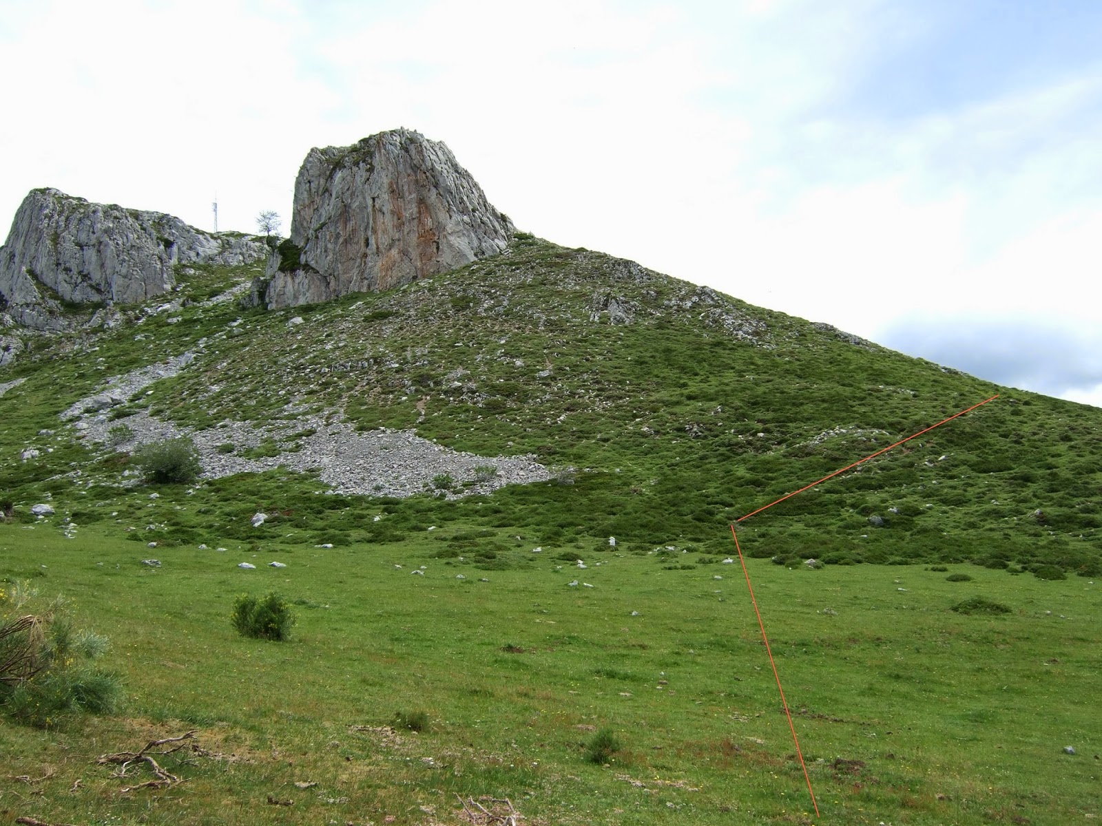
The Escamellau - bringing back memories of last summer; for more see:
El Escamellau nos recuerda una bonita ruta del verano pasado:

We then left the Canal where a couple of barrels had been left to collect water and followed a path up to the right, before turning left into the cloud (hence the absence of photos) and eventually reaching the collado. The view looking towards the other side was of this sea of clouds.
Dejamos la canal donde había un par de bidones para recoger agua y seguimos un sendero que sube hacia la derecha, antes de girar hacia la izquierda y entrar en el último tramo de la subida, hoy envuelto en una nube (que explica la ausencia de fotos) y al final llegar al collado - la última parte se hacía bastante dura. Este mar de nubes al otro lado del collado nos daba la bienvenida.

The Naranjo de Bulnes appears on the left, behind Peña Castil; for views of and from Peña Castil go to:
El Picu se asoma a la izquierda detrás de Peña Castil; para vistas de y desde esta última visita:
We then briefly followed the path up to the left side of Peña Castil before skirting round to the left on the level, and following a few cairns soon reached the "Ice cave", which entails a descent (preferably with crampons) down a steep snowy slope till you get to the floor of the cave completely covered with ice.
Subimos unos 50 metros hacia Peña Castil con tendencia a la izq. para luego seguir sin perder altitud bordeando la montaña por la izquierda; pronto aparecen unos hitos y una senda que llevan a la Cueva de Hielo. Para entrar en ésta se recomienda usar crampones para bajar la ladera nevada y pisar el suelo al fondo, que está cubierto de hielo.


At this point the battery in my camera decided it had had enough, which meant that from then on photos had to be coaxed out of it. For views from inside the Cave go to the following blogs by companions on the walk:
En este momento se empezaba a agotar la batería de mi cámara, y costaba bastante sacar más fotos. Para ver imágenes desde dentro de la Cueva visita los blogs de mis compañeros de ruta:
http://pasoapasoamokas.blogspot.com.es/2014/08/hielo-en-el-desierto.html
http://bttbezana.blogspot.com.es/2014/07/vega-de-sotres-cueva-de-hielo.html

The clouds came and went - here the Morra is visible on the left, and the rest of the Eastern Massif  to the Picos de Cámara to the right
Las nubes iban y venían constantemente - aquí se ve desde La Morra a la izq hasta los Picos de Cámara hacía su derecha.

The summit of Peña Castil at the top of the photo with the entrance to the cave on the bottom right behind the snow
La cima de Peña Castil en el centro de la foto, con la entrada a la cueva hacia abajo a la derecha detrás del nevero

The route taken to the Ice Cave as seen from just below the Collado de Camburero
La parte de la ladera de Peña Castil que se coge para llegar a la Cueva de Hielo desde justo debajo del Collado de Camburero
There was somewhat less cloud as we retraced our steps down the top part of the Canal. Rather than go back the way we had come up, we took a path which you can just make out right of centre down into the Canal del Fresnedal
Había menos niebla en la bajada que habíamos experimentado subiendo. En lugar de bajar por el camino que habíamos usado para subir, cogimos una senda que se intuye en el centro-derecha de la siguiente foto; así entramos directamente en la Canal del Fresnedal
At this point I took the last photo my camera allowed before the battery packed up completely -  looking up to the Collado de Camburero. You'll have to take my word for it that the view in the other direction down to the Vegas de Sotres was stunning, and made for a beautiful descent.
Al llegar a la senda saqué la última foto que me iba a permitir mi cámara antes de agotarse la batería completamente - mirando atrás hacia lo que acabábamos de descender desde el Collado de Cambuerero. La bajada desde ese punto hasta las Vegas de Sotres era preciosa, pero guardo el recuerdo en la retina al no tener recurso fotográfico.

domingo, 6 de julio de 2014

Peña Labra

Peña Labra, seen here from the Cohilla reservoir, is one of the most recognizable mountains in Cantabria. My first walk in the mountains in 2 months (!!) had to be something not too taxing and I had to beat the rain, which was forecast from lunchtime, so I set off early for Piedrasluengas, down to the right from Peña Labra in the photo, in the neighbouring province of Palencia.
Peña Labra se reconoce fácilmente - aquí se ve desde el embalse de Cohilla. Después de 2 meses sin ir a la montaña quería hacer una ruta corta y además la previsión meteorológica anunciaba lluvia para las tres de la tarde, así que la subida desde Piedrasluengas parecía perfecta.


Peña Labra from just a few kms from the Piedrasluengas pass (taken on the way back, like the previous photo).
Tiene este aspecto desde el "Mirador del jabalí", pocos kilómetros antes de llegar al puerto (saqué esta foto a la vuelta, como la anterior)


The views from Piedrasluengas are impressive:
Desde el Puerto de Piedrasluengas las vistas son impresionantes:


I've taken a few photos of the Peña Sagra sierra, but can't think of any I like more
He sacado unas cuantas fotos de la sierra de Peña Sagra, pero ésta es de las que más me gustan


So at 9.30 I crossed the road and began making my way eastwards - the sun was up so I couldn't take many photos; this was taken at the end of the walk
A las 9:30 crucé la carretera y seguí una pista hacia el este - no podía sacar fotos de frente ya que el sol estaba de cara; ésta la saqué al final de la excursión

The next photos are just to show the way up the first part of the walk
En las siguientes fotos la línea roja indica el camino que cogí: la siguiente es al final de la pista 

Después de pasar por un matorral se coge un sendero que va subiendo

Subes bordeando las rocas por la derecha para pasar la antena por la derecha

Al llegar a la altura de la antena subes de frente por una senda que luego atraviesa un matorral antes de virar hacia la derecha y llegar a un abrevadero. Aquí dejas la senda y subes hacia la izquierda

The mist rises up from the valleys as the sun gets to work
Mirando hacia atrás; la niebla matutina de las valles sube a medida que avanza la mañana

A steep walk up through the broom takes you up to the foot of the ridge
Aquí empieza una senda empinada a través de la retama que te lleva hasta el pie de la cresta


Then you head to the right towards Tresmares
Luego vas hacia la derecha en dirección a Tresmares

A left turn takes you to the summit. To the right lie Peña Sagra and the Nansa valley far as the Cohillos reservoir. The previous entry on this blog was a walk along the final stretches of the same river.
A los 15' giras a la izquierda, subes un poco y ves la cima. A la derecha se ven Peña Sagra y la parte alta del valle del Nansa hasta el embalse. En la entrada anterior de este blog el protagonista era la parte baja del mismo río.

Looking east towards the Cornón and Tresmares: the bad weather was on its way
Hacia el este el Cornón y Tresmares - llegaban las nubes

Views from the top:
La panorámica desde la cima:
La Pernía

Curavacas y Peña Prieta

Coriscao y Picos de Europa

From the north end of the ridge
Desde la parte norte de la cresta
Zooming in on the Picos
Los Picos con el zoom

Sejos y el Cornón con Castro Valnera a lo lejos

After a good while spent admiring the views I made my way down via another path
Después de pasar un buen rato disfrutando de las vistas bajé por otro camino


Part of the attraction of this walk had been the chance to see the 10 kms of road between Pejanda in Polaciones and the point where it joins the road from Ojedo. At the Cruz de Cabezuela I was taken by this statue, showing a meeting between people from the Polaciones and Liébana valleys
Un placer añadido de esta excursión fue la oportunidad de recorrer los 10 km entre Pejanda y el cruce con la carretera que sube desde Ojeda. En el Mirador de la Cruz de Cabezuela me llamó la atención esta estatua: "Encuentro de purriego y lebaniego"- me consta que no todos los de Polaciones miran con buenos ojos a los de Liébana y el turismo que consiguen atraer.

And to finish, Peña Labra from the same spot
Para terminar,  Peña Labra desde el mismo mirador