jueves, 25 de agosto de 2022

El paisaje pasiego / the Pas valleys


"No hay mal que por bien no venga" ha sido uno de los primeros refranes españoles que aprendí. Desde luego puede aplicarse al día que fui a Vega de Pas pensando subir por el km vertical. Al encontrar la carretera cerrada en Portilla (y sin ningún tipo de indicación en la página web de la DGT) tuve que replantear mi idea. Por suerte vi una indicación de la ruta Portilla - Aguasal (PR S 63) y  ya que había cobertura en la zona pude descargar un track de esta ruta.
Si no hubiera sido por las obras no habría descubierto esta ruta tan bonita que traza un recorrido similar al del kmV ya que se dirige hacia Castro Valnera pero acaso con mayor variedad de paisajes.
Every cloud has a silver lining, as they say. This definitely applied the day I was prevented from doing the hike I'd planned due to the approach road being closed. Fortunately I saw signposts for a different walk, which turned out to be a great alternative.

Para empezar, una subida suave por Los Perales - un bosque de robles y hayas 
To begin with, a gentle walk up through oak and beech woods


Al salir del bosque sigo la ascensión tranquila de cabaña en cabaña, disfrutando de las vistas de los montes y valles que me rodean. Ya se ven por ejemplo los Picones de Sopeña, enmarcados en la ventana de una cabaña abandonada
When I came out of the woods the ascent took me past the stone huts typical of the Pas valleys. Some are abandoned, like this one - what used to be a window framed the nearby Picones de Sopeña range

La ruta sigue para arriba. Se ve Castro Valnera al fondo, y luego bajaremos hacia ese lado del monte 
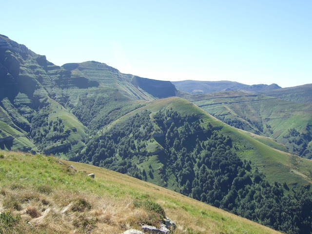
Carrying on upwards, Castro Valnera mountain comes into view - later I'll be going down towards the right and will see it in more detail

Aunque los praos no se ven muy verdes hacia el norte, las estribaciones de los picones sí lo están
Although the meadows to the north aren't very green, the spurs coming down from the mountains look as I remember them to have been

Dejo la bajada para más tarde y subo un poco más hasta el Cueto de Hormías, delante de la Len Hermosa y el Picón de los Lastreros -  hace ¡12 años! que no andaba por esa zona
I leave the descent for later and continue on up to a vantage point right in front of the Len Hermosa (beautiful slope) and another summit to the right I hadn't been to for 12 years

A la izquierda el Coterón
The continuation to the left

Una mirada hacia la derecha. Por ahí habría andado si hubiera seguido la ruta planeada. Decido bajar la cuesta un poco en esa dirección
Looking towards the right. That's where the planned walk for the day would have taken me. I decide to walk down a bit to get a better view.

y ver mejor la majestuosidad de Castro Valnera
and see Castro Valnera in all its majesty

De vuelta a la colina desde donde podré retratar buena parte de la subida hecha
Back up to the hill where I'll be able to see a good part of the walk I did earlier on

esta es la lengua verde por la que subí. Ahora bajaré un poco para girar hacia la izquierda y reencontrarme con el PR.
So this is the gentle ridge I walked up. I'll now go down past the cattle and follow a signpost down to the left

Vamos para abajo pero ¡no tan directamente!
I'll be going down to the river but not so directly!

Un sendero nos llevará desde la parte baja de este prao por los helechos hasta el fondo del valle. Me alegra ver que hay algo de agua en la cascada de la Canal de la Vara
From the bottom of this meadow a path takes me down past the bracken to the foot of the valley. I'm happy to see the waterfall is visible

aquí está con zoom - serán los dos días de agua que proporcionan el chorrito
Here's a close-up - two days of rain mean at least there's a trickle of water

Bajamos en zigzag hasta las cabañas abandonadas que se ven a la derecha
Zigzagging my way down to the abandoned huts down to the right

No resisto a subir otra foto de una de mis dos montañas favoritas de Cantabria
I can't resist posting another photo of one of my favourite mountains in Cantabria

Una visita a las praderas de Aguasal. No voy muy lejos porque aprieta el calor. Cuando vine por aquí por primera vez seguí hasta la cascada
A visit to the Aguasal pastures. I don't follow the stream for long though as it's getting pretty warm. The first time I came to this spot I carried on as far as the waterfall

Los colores de ¿un otoño adelantado?
Looks like autumn might be earlier this year

Bajo hasta el río y pronto llego a La Estribera - donde quería haber aparcado por la mañana. Pero ya que la carretera está cerrada me quedan 4 kilómetros de asfalto hasta llegar al coche. Por lo menos él de la excavadora paró un momento para dejarme pasar.
Pues lo dicho; posiblemente no hubiera descubierto esta ruta si no fuera por la obra - a pesar del tramo final por la carretera me ha parecido preciosa.
I go back to the main route and carry on down to the river, soon reaching La Estribera, which is where I would have set off from if I'd been able to drive there that morning. So I'm left with 4 kms along the road to get to the car.  At least the guy operating the excavator stopped a moment to let me get by.
As I said before, if it hadn't been for the roadworks I might never have discovered such a lovely walk, the last section notwithstanding.

Por último, la cascada como la veía en abril del 2008
Finally, the waterfall as I saw it in April 2008


sábado, 20 de agosto de 2022

Moncayo- una cumbre con historia/a mountain with history

De vacaciones en Soria, tenía en mente aprovechar la proximidad para subir el Moncayo, la cumbre más alta del sistema ibérico. Antes del día de la subida no tenia información sobre el origen del nombre, que parece que viene del latín Mons Caius, que podría significar montaña cana, por el aspecto que le confiere la nieve durante gran parte del año. Una explicación alternativa, en este caso mitológica, es que el nombre deriva del gigante Caco, que aparte de tener sus más y sus menos con Hércules, supuestamente habitaba una cueva, que algunos han imaginado podría ser la de pueblo de Cueva de Ágreda. Pues hasta allí fui para comenzar la ascensión. Al coger el coche más tarde para volver a la ciudad veía la cueva delante de mí dominando el pueblo.

Empecé a caminar temprano para poder hacer la mayor parte de la subida antes de que el sol me llegara a molestar. La ventaja de subir desde el lado soriano es que vas hacia el este, y puedes andar en sombra. A las 7:45 tenía este aspecto mi objetivo (el Moncayo es el de en medio, que apenas se ve).

A holiday in north-central Spain gave me the opportunity to climb a well-known peak, which is the highest in the Iberian system mountain range. The Moncayo owes its name to the Roman conquest of Spain and is part of the border between Castile and Aragon.
As it is hot in summer I had to make an early start if I wanted to get to the top before the heat became too punishing. Fortunately, as I was walking up the western side I'd be shielded from the sun for most of the ascent. So at 7.45 this was the view I had (Moncayo is the one in the middle, that you can hardly see).

Había descargado una ruta por si las moscas, pero el camino está claramente balizado, y la primera parte atraviesa un robledal. Hablando de moscas, me dio mala espina la cantidad de insectos que me asedian, y llegué a imaginar mi propia interpretación del nombre del pico, a saber: Mo(scas que me ha)n caí(d)o. Por suerte al salir del bosque empezaban a molestar cada vez menos...
Lots of flies during the first part of the hike, through an oak wood, but luckily their presence diminished as  I left the trees behind

La parte más bonita de la ruta, siguiendo un arroyo hasta el barranco que sube hace la cima
This was the prettiest part of the walk, following a brook which leads to a gully that will take me towards the summit

Poco después de empezar a subir por el barranco miro atrás para ver como la sombra se va reduciendo 
Not long after I began walking up the ravine I glanced back to see that the shadow was getting smaller and smaller

Me acercaba a la salida del barranco cuando los rayos de sol empezaban a asomarse
I was nearing the top of the gully when the sun's rays began to appear

Al llegar a la divisoria me acerco al lado aragonés. Veo un par de embalses, pero está todo muy seco y debido al aire cálido no se ve con mucha nitidez. Me da la sensación de estar mirando por la ventanilla de un avión.
On reaching the watershed I looked over at the Aragon side. A couple of reservoirs were visible down below but it all looked pretty arid and owing to the warm air there wasn't much clarity. I felt like I was on a plane looking through the window 
 
Hacía la izquierda queda la cima. Ya bajan un par de senderistas
The summit is just over to the left. A couple of walkers are coming down already

Así se ve la cumbre
And this is what the summit looks like

Hacia el norte se ve una localidad que creo que puede ser Ágreda
Towards the north the town you can see must be Ágreda


Hacia la vertiente occidental                                                                                                                             Looking towards the west

A los pocos minutos de estar en la cumbre empezaban a llegar senderistas y corredores que habían subido desde el lado zaragozano por el cerro que se ve hacia el sur
A few minutes after I reached the top, hikers and trail runners who'd come up from the other side started appearing from the southern part of the ridge

Vuelvo por el mismo camino por el barranco entre la cima y el cerro de enfrente.                                                    I went back down the same route I'd come up


Una mirada atrás cuando ya he salido del barranco
A look back once I'd come out of the ravine

Al salir del robledal veo la iglesia de Cueva de Ágreda
As I come out of the oak wood I see the church tower in Cueva de Ágreda, the village I set off from

Y al poco de salir del pueblo miro atrás. El Moncayo está en el centro de la imagen
And just after leaving the village I stopped to look back. Moncayo is in the centre

Los historiadores hablan de la batalla de Mons Chaunus (latinizada posteriormente a Mons Caius) entre romanos y celtíberos en 179 a. C.  Se da por hecho que el nombre se refiere al Moncayo aunque es más probable que ocurrió al lado del este. A su fin se firmó un tratado entre el general Graco y los celtíberos al pie de la montaña. La paz duró unos 30 años hasta el comienzo de las Guerras Celtibéricas, que terminaron con el famoso asedio de Numancia.
Moncayo was the setting for a battle in the 2nd century B.C. between the Romans and the Iberian Celts. This ended with a treaty signed at the foot of the mountain bringing peace for thirty years until the outbreak of war between the two sides.

Debo decir que la historia que rodea esta cumbre tiene casi tanto interés como la subida en si, pero es una apreciación particular, y seguramente la ruta es más bonita en invierno.
I must say the historical references to the mountain are almost as interesting as the walk up to the top itself, though it was probably not the best time of year to appreciate the place.