domingo, 8 de agosto de 2021

In memory of Truck / Via Verde del Pas

As I look through photos and remember the moments from the past months that make up this walk, done over half a year on odd Saturday or Sunday mornings, one fact stands out. When we began the Vía Verde Truck was still with us; by the time we had finished he was not. 
So this is dedicated to you Truck. Forever alive in our memory!

At the end of 2020 Carmen and I decided to check out the walk from Astillero to Ontaneda, which follows the route of a disused narrow-gauge railway line. It's about 35 kms, but we would do it in short stages,  walking between one and two hours each time, including going back the way we'd walked. As it turns out, it was lucky that we started last year as the first leg, which crosses the Solía estuary via an old railway bridge, is currently out of bounds as the bridge has been closed for repair.
A finales del 2020 Carmen y yo decidimos probar la Vía Verde del Pas. De Astillero a Ontaneda son unos 35 kilómetros, pero íbamos a hacerlos en tramos, andando entre una y dos horas cada vez. Tuvimos suerte, porque todavía estaba abierto el puente que cruza la Ría Solía al dejar Astillero - se cerró pocos meses después.

The route is primarily for cyclists, which means that we had to keep Monty on the lead most of the time so as not to impede their progress. But he was more than happy to come along with us so that wasn't a big problem. The only stage he missed was the last one, as by then it was a bit hot for him. The first ones though took place at the beginning of winter. This tree near Liaño illustrates how the growth of branches is affected by how much sunlight they get.                                                                                                                      

La Vía está pensada sobre todo para ciclistas, así que había que mantener a Monty con la correa para evitar tener que estar constantemente mirando hacia atrás. Pero le han gustado los paseos, salvo el último, cuando no lo llevamos porque hacía ya calorcillo. Las primeras etapas, sin embargo, ocurrieron a principios de invierno.  Este árbol, que pasamos en la segunda etapa demuestra cómo la luz solar afecta el crecimiento de las ramas.


This photo prompted a discussion as to whether this landscape could be England.
Recuerdo que este paisaje me recordaba mucho Inglaterra

Rosequillo park in La Concha was one of the many interesting discoveries we made along the way. Just after that you go past one of the entrances to the Cabárceno wildlife park. The walk goes through Obregón, and then there's a section that is fine for cyclists, as it skirts round Sarón, but for walkers, I think going through the town is probably a better option. The sector from Sarón to La Penilla introduces an element not seen thus far: the walk goes alongside the river - but it's the Pisueña not the Pas. Also, just outside the town is this intriguing looking building, which was being renovated for public use when the pandemic hit.
Hay un par de etapas que permiten volver por un camino distinto. Una de ellas nos llevó a la finca Rosequillo en La Concha - un descubrimiento bonito. Más adelante bordeas el parque de la naturaleza Cabárceno. A continuación Obregón, y luego un tramo nuevo hecho para que los ciclistas puedan rodear Sarón. Sin embargo, recomendaría a los caminantes entrar directamente en el pueblo. Entre Sarón y La Penilla un elemento nuevo aparece al lado de la vía: el río, pero no es el Pas, sino el Pisueña. Además, al salir del pueblo vemos este edificio llamativo, que estaba en el proceso de renovación para uso público cuando llegó la pandemia.

La Penilla is probably best known for a factory I don't wish to give publicity to, but especially on the next stage to La Cueva, the smell of chocolate added an olfactory element only matched by the aroma from the biscuit factory in Aguilar de Campoo!
La fábrica más conocida de La Penilla, a la que no voy a dar publicidad, se notaba sobre todo en el siguiente tramo, a La Cueva: el olor a chocolate impregna el entorno, un poco como la fábrica de galletas de Aguilar de Campoo 
Pisueña (La Penilla)


The part of the walk that we started in Pomaluengo was the farewell to one river and welcome to the one that would accompany us to the end, and which gives its name to the route: the Pas. In fact, we were becoming so fond of the Pisueña that we went back another day and did a lovely walk from Pomaluengo following the course of the river.
El tramo desde Pomaluengo comienza con el reencuentro con el Pisueña, que luego pasa el testigo al Pas. Uno de los muchos caminos adicionales que se nos iban ocurriendo mientras hacíamos la Vía Verde era uno que sale de Pomaluengo y sigue el curso del Pisueña.
Pisueña

Anyway, the Pisueña heads off towards Vargas, where it flows into the Pas, which we encountered on our way to Puente Viesgo
De todas formas, el Pisueña sigue su propio camino hacia Vargas, donde se encuentra con el Pas. La Vía  empieza a seguir este durante el camino a Puente Viesgo. Otro paseo muy recomendable que descubrimos es el camino entre la confluencia de los dos ríos y Carandía.
Pas
The Puente Viesgo stage gave us the opportunity to go back to our start point via the "Anglers' Path"
La etapa de Puente Viesgo nos dio la oportunidad de volver por otro camino: el Sendero de los Pescadores
Sendero de los Pescadores

The walk leaves the banks of the Pas as it enters the Toranzo valley, a part of Cantabria I'd only really seen from a car window on the way to the Escudo. A right-wing mayor in this area a few years ago had turned me against the area, but I must say I enjoyed walking through it.
Nos alejamos algo del río al entrar en El Valle de Toranzo, una parte de Cantabria que estoy más acostumbrado a ver desde el coche, camino al Escudo. A causa de cierto alcalde se me quitaron las ganas de visitar este zona hace unos años, pero debo decir que esta caminata me ha reconciliado con el valle.
Monasterio de Soto-Iruz 


By now we were well into spring, and the changes in the landscape brought about by the advent of a new season was another positive element to our peripatetic weekend outings
Ya estábamos en primavera, y los cambios en el paisaje a medida que pasaban las semanas han sido otro elemento para resaltar de nuestro trayecto.

I was surprised to come across this aqueduct near Santiurde de Toranzo
Me sorprendió encontrar este acueducto cerca de Santiurde de Toranzo

Near San Vicente de Toranzo we crossed the iron railway bridge, and rejoined the course of the river Pas
Cerca de San Vicente de Toranzo cruzamos el puente de hierro del ferrocarril y conectamos de nuevo con el río Pas
Puente de Hierro


We came to the end of the walk in Alceda, more than six months after taking the first steps. 
Llegamos al final de la ruta en Alceda, muy satisfechos con el resultado y agradecidos a Alfonso, quien recomendó esta ruta llana, accesible para todos los públicos.
Parque de Alceda


 Dedicado a la memoria de Laurence "Truck" South 

miércoles, 28 de julio de 2021

Cailagua / a waterfall in summer

Aparcamos en el barrio de San Antonio cerca de una ermita. (Al salir de Asón se coge el 2º camino que baja a la derecha, siguiendo la indicación de la PR-S.14.) En seguida cruzamos el río y vamos a la izq. por una calzada. Continuando en la misma dirección llegaremos sin pérdida a la cascada más conocida de Cantabria. Se considera el nacimiento del río Asón, que vemos de vez en cuando a nuestra izquierda. En una bifurcación decidimos seguir por el mismo lado del río, volviendo más tarde por una senda al otro lado que nos traería a este mismo punto.
This is a short walk from Asón (follow the signposted PR-S.14 route that starts south of the village. There are a few parking spaces near the cemetery). After a few hundred yards we cross the river Asón and take the stony path on the left. Carrying on in the same direction we'll eventually get to the most famous waterfall in Cantabria, also the official source of the river, which we see from time to time as we follow the gentle walk. When we reach a fork, we decide to continue on the same side of the river, and return via a path on the other side which will bring us back to this point.

Un poco más tarde encontramos esta roca enorme en el camino que nos obliga a rodearla por la derecha
Shortly afterwards we come across this enormous rock which forces us to go round to the right

y a partir de aquí hay cada vez más rocas en el camino
From now on there are more and rocks along the way


Siguiendo la senda balizada subimos hacia la derecha y en seguida vemos la cascada delante de nosotros
Following the signposts, we head up to the right and see the waterfall ahead of us


Mirando hacia la izquierda en dirección a los Collados del Asón
To the left is the head of the valley: a starting point for lots of walks

En esta época veraniega no hay mucha agua, pero me encanta la variedad de efectos que produce durante su caída, golpeando y deslizándose por la roca
During the summer there's not much water, but I was really taken by the diverse effects the water makes as it plunges, bounces and glides down the rock face


En la última parte de la bajada me fijo en los farallones al lado derecho del río
On the way back I pay attention to the cliffs on the right side of the river

Más arriba están la Rasa y el Mortillano, aunque no se ven desde aquí
Unseen further up lie the Rasa and Mortillano mountains


Y cerca ya del Bº San Antonio se intuye la entrada al barranco de Rolacía a la izquierda
Almost back at the starting point, and on the left you can make out the entrance to the gorge that leads up to Porracolina mountain.

¡Qué bien que Carmen haya podido acompañarnos en una excursión por el monte!
This was a red-letter day for Carmen, as she was able to accompany us on a hike after missing out for so long!


jueves, 15 de julio de 2021

Alto las Verdianas: ¡A la 4ª la vencida! / At the 4th time of asking

Salimos del aparcamiento del Cdo de Hoja, confiando que esta vez la meteorología no nos impediría llegar a nuestro objetivo. Disfrutamos como siempre de las vistas bonitas de las sierras que rodean Bejes.
We set off from the carpark above Bejes, hopeful that bad weather would not intervene this time. As usual we enjoyed the views of the mountain ranges that surround the village.
Macizo de Peñarrubia

La Cerralosa

Peña Ventosa y Peña Sagra

Nunca puedo resistir sacar una foto de este abrevadero 
The most photographed water trough on these pages!  

En la última excursión por aquí renunciamos por la niebla y subimos el Cueto de la Llosa (centro-derecha) 
Last time we were here low-lying cloud prevented us continuing beyond the Puerto de las Brañas and we walked up the hill you can see centre-right before returning to base

La entrada a la Canal del Valle
The entrance to the gorge

Pasamos un buen rato en un atasco de vacas que solo conseguimos adelantar un poco antes de la Canal del Valle
A bovine traffic jam held us up a bit and it took some time to get ahead of the herd 

La Canal del Valle

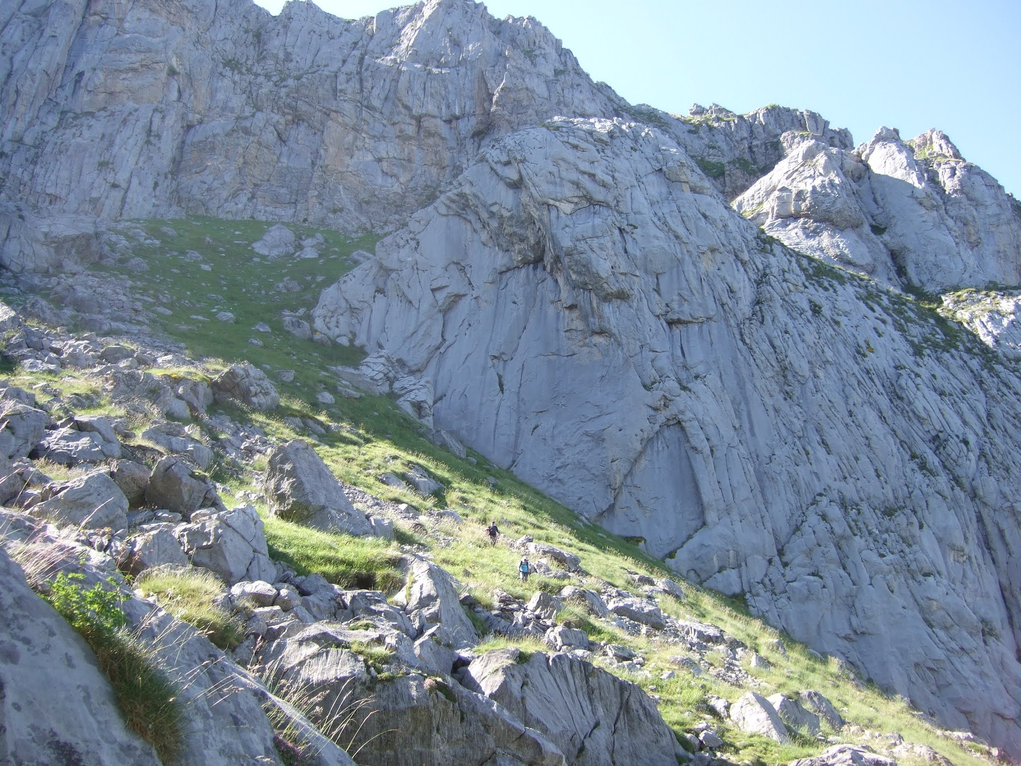
Desde el Cdo de la Llaguna en lo alto de la canal vemos como las nubes suben sin parar. Nos quitarán vistas pero no impedirán la subida
The view from the top of the gorge. The clouds were to take away most of the views but at least they didn't stop us in our ascent

La laguna esta en la parte izquierda del collado, pero hay que subir hacia el lado derecho para arrimarse a la Paré Corvera
There is a pool is on the left, which gives the pass its name, but to continue the walk you have to go up to the right and find a path at the foot of the cliffs

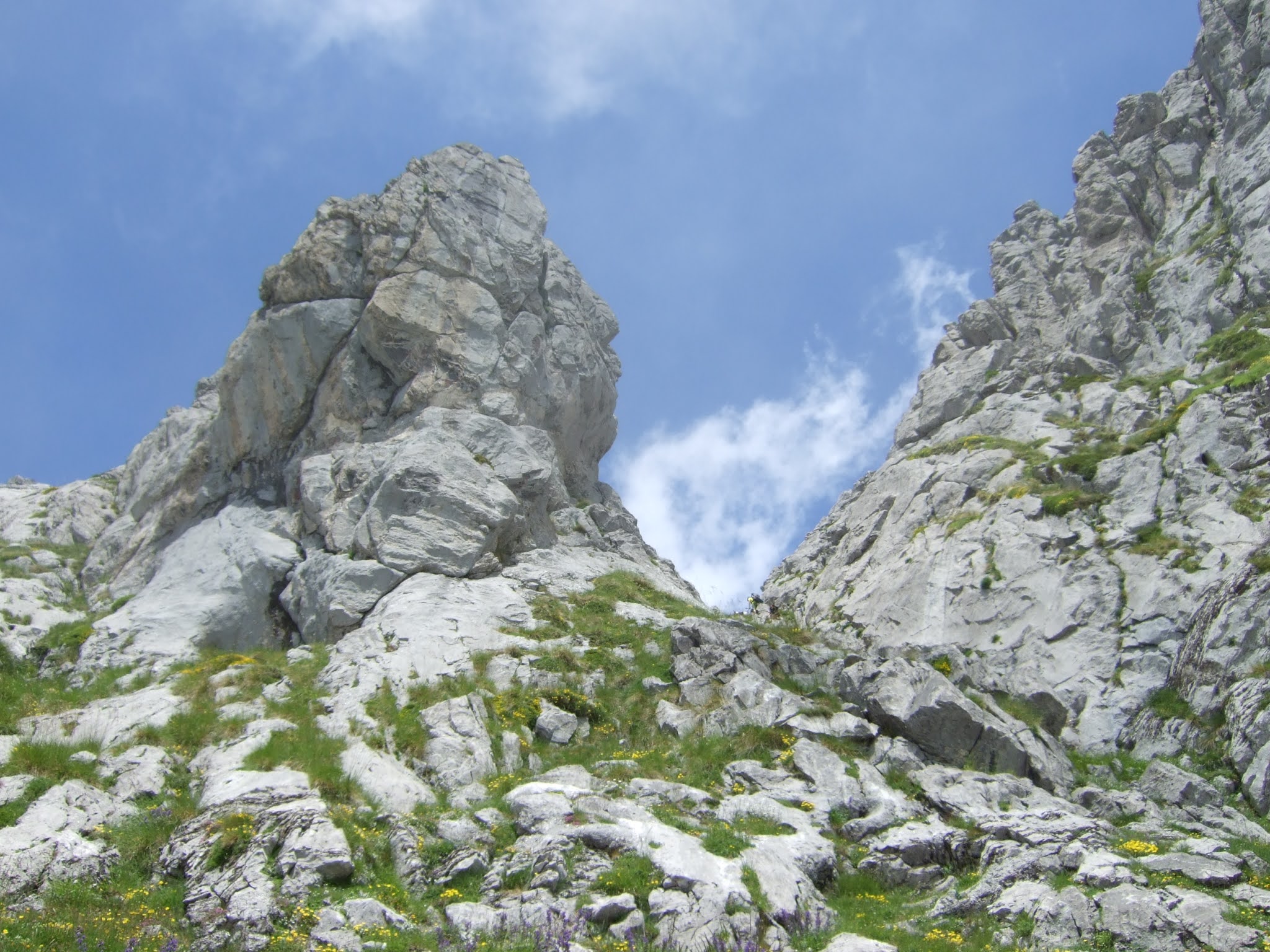
Vamos en dirección a la Canal de San Carlos, bordeando la pared hasta intuir el Rendijón, que ofrece una subida a la parte de arriba de la Paré Corvera. Antes de llegar hasta allí, sin embargo giramos a la derecha por esta entrada entre las rocas. Esta es la Hendida, que nos habían recomendado coger.
We follow the cliff westwards as far as a point just after going round a large rock, where a narrow entrance appears to our right. It's easy to miss as a more obvious gap in the cliff-face seems to be just ahead. This is the Hendida, and we'd been recommended to take it rather than the Rendijón just a bit further along.

En seguida el sendero nos lleva a esta perspectiva por encima de la pared
Very soon the path brings us to this point, with views above the cliffs

Giramos hacia la izquierda y vamos hacia la canal
We bear left and go up towards the gully

Es una trepada sencilla y divertida
It's an enjoyable scramble up


Al salir de la Hendida, vemos el Samelar 
On coming out we see Samelar ahead of us

y una montaña más baja que visité la última vez que estuvimos en el Samelar
and a slightly lower mountain I explored last time we were on Samelar
Canto la Concha


Fuimos hacia lo que suponíamos era la parte más alta de Paré Corvera (centro) pero cuando llegamos, nos dimos cuenta que habíamos dejado la cima atrás a la derecha
We walked up to what we supposed was the highest point of the clifftops (centre) but when we got there, we realised we'd left the summit behind on our right


Así que subimos un poco hacia la pila de piedras que indican el Alto las Verdianas. Tuvimos que esperar un rato hasta poder disfrutar de vistas parciales del oeste y el sur
So we made our way to pile of rocks that mark the Alto las Verdianas. We had to wait a while to be able to enjoy partial views to the west and south
Samelar


Mi idea había sido seguir por Las Becerreras, hacia el norte, y luego bajar hacia la derecha y alcanzar la pista en el Puerto de las Brañas, pero la nube nos iba a quitar las vistas
My original idea had been to descend by heading towards the north and then going down to the right so as to get back onto the trail we came up on, but the cloud would have left us seeing nothing


así que decidimos volver por la arista donde habíamos estado hacía pocos minutos y seguir hasta un paso que nos llevaría a la Canal del Valle otra vez
so we decided to go back along the ridge to where we'd been a few minutes previously and then continue as far as a pass that would take us back down to the Canal del Valle


Aparece el collado de la llaguna
The pool comes into sight down below
Collado de la Llaguna

Canal del Valle

y llegamos a Treslaparé, donde arranca el Sendero del Palo. No teníamos información sobre el estado de esta senda. La primera parte baja por una zona herbosa
We got to the point where the Sendero del Palo starts. We had no idea what this path was like except that it existed. The first part runs down a grassy slope

y luego hay alguna zona un poco expuesta antes de subir por la cuesta de la foto
and then a continuation where you have to be very careful not to miss your footing before making your way up the next knoll

Nada más empezar a bajar por el otro lado hay un destrepe que precisa de buena técnica o (como en mi caso) de piernas largas.  
As soon as you start the descent on the other side there is a tricky section to climb down which requires good technique or (as in my case) long legs. 

Luego a bajar, entrando brevemente al campo visual de un espectador hipotético en la Canal, antes de volver a subir. Finalmente la lengua herbosa te saca a espacios más suaves y se puede bajar a la Canal del Valle tranquilamente
Thereafter, you carry on down, reappearing briefly to a hypothetical onlooker from the gorge below, before going up the next grassy bank. Finally you reach a gentler section and can follow the grassy patch down to the left and make your way to the Canal del Valle

A esta foto de octubre del '19  he dibujado por donde va la parte del sendero que sería visible desde la zona alta de la Canal del Valle
On this photo from October '19 I've marked the part of the path that would be visible from higher up the gorge 


Y para acabar, la parte baja de la canal florida
A flowery conclusion, near the bottom of the gorge

Aunque el Alto las Verdianas es la cumbre más oriental de Picos de Europa que supera los 2000 metros no es especialmente vistoso. Lo más llamativo de esta ruta han sido los accesos al mismo. Y el hecho de que en otras ocasiones el no encontrar el camino, el viento o la niebla parecían haberlo convertido en ¡una montaña maldita! 
Finalmente, El Sendero del Palo no es una bajada recomendable para el senderista medio. 
Although Alto las Verdianas is the easternmost summit in the Picos de Europa to exceed 2000 metres, it doesn't really stand out. The most memorable part of this excursion were the points of access to and from the ridge. Added to that, after previous failed attempts, owing to not finding the gully up from the pool, the strong wind or the fog, it was satisfying to tick it off the list! 
N.B. The Sendero del Palo is not a path I would recommend to the average hiker.

 El track de la ruta: