Ha sido en el 2021, cuando realicé unas cuantas excursiones por los pueblos y macizos de Soba, que me eché el ojo a la Canal de Ancillo, aunque la conocí como Camino de San Pedro, ya que la oteé por primera vez desde este pueblo. No apetecía recorrerla y acto seguido desandar lo andado, pero la orografía de la zona no ofrecía soluciones obvias para un recorrido circular. Así que cuando encontré un track que permitía superar este escollo lo guardé para el momento propicio.
It was only four years ago that I set eyes on the Ancillo gorge. I didn't fancy walking through it and then coming back the same way, so when I found a way to get round having to do this this I put it on my list.
Salí del lado de Ancillo, un barrio cerca de Ramales, y me metí en un bosque cerrado del tipo mediterráneo.
Setting off from Ancillo on the northern side of the gorge, I spent the first part of the walk following paths through Mediterranean scrub

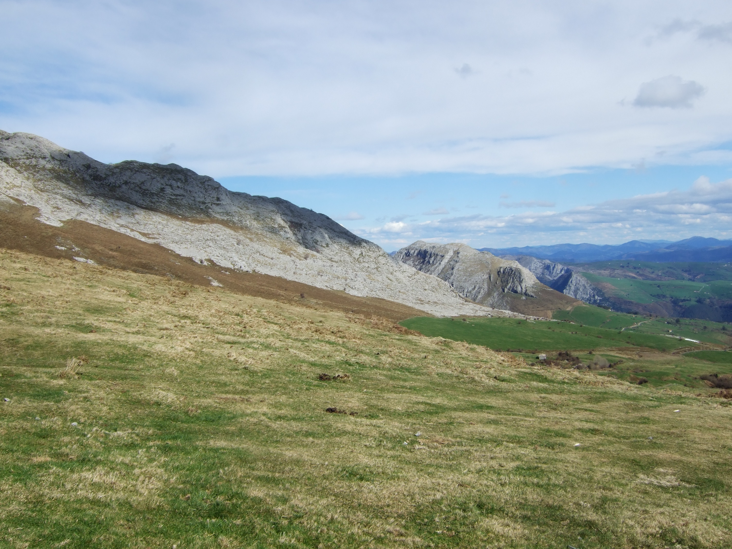
Por encima de donde había aparcado se levantan la Sierra de Rozas (izq) y la de Hornijo, y se intuye la Canal de Ancillo que divide las dos - pero eso para luego...
I'd parked down below the two ranges that separate the gorge; Rozas on the left and Hornijo on the right


Con vistas bonitas a la Sierra del Hornijo

Es terreno calcáreo
This is limestone country

Nice views of the Hornijo Sierra


y la del Pico San Vicente y Sierra de Rozas


and the back of San Vicente Peak and Rozas Sierra

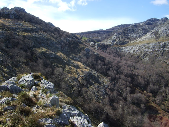
En este punto dejo atrás la vegetación y continúo por la izquierda, pasando cerca de varias depresiones

This is where I get above the vegetation and carry on to the left, going past various depressions on my way

Peña Rocías forma una de las paredes que encierran el Hoyo Masayo

Peña Rocías provides one of the walls that enclose the Hoyo depression, to which I'm headed


Desde el borde del Masayo hay una vista al Buciero

Pero antes paso cerca de un hoyo mucho más pequeño, pero muy bonito.
But first there's a much smaller depression, though very pretty nonetheless.


En estas alturas sopla bastante el viento y hay que andar con cuidado por este terreno
It was getting quite windy at this elevation so I had to tread carefully

From the rim of Masayo there's a decent view of the Buciero and Santoña on the coast

Se ve el camino que sube desde Riba en el fondo del Hoyo

At the bottom of the despression you can see the trail that comes up from Riba
Sigo un sendero que baja en diagonal hacia la salida del sur
 |
| Hoyo Masayo |
I took a path that descends diagonally towards the southern exit
Una mirada hacia atrás para ver por donde he bajado

A look back to see where I came down

Me mantengo a unos cien metros por encima del fondo siguiendo lo que quedaba de un viejo sendero

I stayed about 100 metres above the bottom, following the remains of a path


Subo por el sendero ya visitado en otra ocasión y miro atrás al Hoyo Masayo

Este me lleva casi hasta el PR, balizado recientemente por Naturea
This brought me near to a signposted route

I carried on up this trail I'd walked four years ago, looking back over Masayo on the way

y abajo a mi izquierda, donde está el precioso Hoyo Salzoso

and on my left the beautiful Salzoso depression

Al llegar arriba veo una silueta muy conocida enfrente

 |
| Hoyo Salzoso |
Al llegar arriba veo una silueta muy conocida enfrente
When I reached the top of the hill I was greeted by well known mountains across the way
 |
| Peña Lusa & Picón del Fraile |
Paso por debajo de otro conocido punto de referencia
The next stage of the walk goes past another familiar landmark
 |
| Peña del Mazo Grande |
El Pico de Hornijo ahora está a mi izquierda y abajo queda la Peña Rozas con la Canal entre los dos
The Hornijo Sierra is now on my left, while Peña Rozas is lower down, with the gorge between them

En esta zona estoy supuestamente siguiendo el trazado del GR-74, pero desde que se publicó la ruta en el 97 se ha descuidado muchísimo. Parece que sólo es el ganado que recorre el camino, aunque mientras voy bajando se me ocurre que quizás esto sea una forma más auténtica de transitar por una senda antigua.
Hacia mi derecha está la bonita estampa de Soba
I'm now supposedly on GR- 74 footpath (Eastern corridor of Cantabria), but since it was first publicised in '97 it hasn't been well maintained. It feels like it's only used by cattle and horses, though as I make my way down it occurs to me that maybe this makes a footpath that aims to follow traditional trails more authentic.
To my right a view over Soba


Las vistas hacia arriba me gustan

Después de un buen rato llego a la entrada de la Canal, con ganas de pisar el Camino de San Pedro (pueblo que está detrás de mí) por fin. Al fondo está la Sierra de Alcomba, visitada hace mes y medio.
After a good while I get to the entrance to the gorge, looking forward to finally setting foot on the San Pedro way (the name comes from the village that's just behind me). Beyond the far end is the Alcomba Sierra, which we visited a month and a half ago.

Looking upwards provides impressive views
pero la pista que recorre la vaguada no me hace nada de gracia, y cuando puedo la abandono y durante un tramo corto consigo seguir el Camino original
 |
| Sierra del Hornijo |
 |
| Sierra de Rozas |
but the ugly track that runs through the gorge is not at all what I had anticipated, and when I can, I abandon it and for a couple of hundred yards I seem to be on the original pathway

pero casi en seguida la pista lo come. Llama poderosamente la atención esta placa al lado de otra salida de la pista

but it's soon absorbed by the track. This plaque along the way reads: "Here Pedro Pérez de Soto lost his life, for it pleased God"

Me resigno, y sigo bajando por la pista por un hayedo bonito. Al salir de la Canal veo claramente el Cubrillu, desde donde mirábamos hacia esta Canal mientras andábamos al pie de la Alcomba hacia la derecha

I give up on the paths and carry on down the track through a beechwood. At the mouth of the gorge I see Cubrillu just opposite; from there we observed this gorge as we walked past the foot of the cliff to the right

La Sierra de Rozas vista desde el final de la Canal

Sierra de Rozas seen from the Ancillo end of the gorge


Más de una vez había topado con postes del GR-74 sobre todo por los Collados de Asón, pero esta ha side la primera vez que estaba consciente de que estaba siguiendo un tramo. ¡Qué triste que ya lleva tiempo deshomologado!
Por lo menos conseguimos recorrer el GR-71 en el 95 nada más venir a vivir a Cantabria. ¡También se encuentra deshomologado!
From time to time I've come across GR-74 footpath signposts in the SE part of Cantabria, but this was the first time I'd been actively following a section of the way. It's a real shame that it's come off the list of recognised paths.
At least we managed to walk the Saja Reserve way in '95 just after we moved to Cantabria - that's also come off the list!
Para acabar, la vista desde Cubrillu, enfrente de la Sierra del Hornijo, la Canal de Ancillo a la izquierda. El camino de hoy cubre el terreno hacia la derecha y el círculo se cierra por el otro lado del macizo.
To finish, here's the view we had from Cubrillu, opposite Hornijo Sierra, with the Ancillo gorge on the left. Today's walk covers the ground towards the right and then returns on the other side of the range.
 |
| 24/01/25 |
No hay comentarios:
Publicar un comentario
Please feel free to leave a comment!
¡Agradezco tus comentarios!