En lugar de subir al Mancondíu yendo por la pista desde el Jito de Escarandi y luego a la Collada Tresmancondíu detrás del refugio, quería probar una ascensión que se me ocurrió viendo un programa de Edurne Pasaban. En la primera curva a la derecha de la pista cogí un sendero a la izquierda. Aquí se ve donde comienza y como discurre por debajo de la pista. Al fondo está el objetivo del día.
The usual way to get to the top of Mancondíu is to go up to the refuge via the track that leaves Jito de Escarandi above Sotres (Asturias) and then go up round the back as we look at the mountain here. Having done that some years ago I wanted to try walking up the northern slope and also avoid the track. So at the first bend to the right I took a path to the left, which you can see runs parallel to and below the track.
El sendero baja a la pequeña vega de la Majada de la Jazuca. Aquí me habría ahorrado tiempo yendo a la izquierda pero no vi ningún hito y subí por la cuesta a la derecha de la foto siguiendo la línea de rocas. Subiendo me di cuenta del error al ver el trazado de una senda hacia mi izquierda y crucé hasta allí
Soon afterwards it runs down to a flat grassy area where you should bear left

bordeando la roca al lado de los arbustos cogí la continuación de la senda que sube por una canal hacia la derecha
I went a bit to the right by mistake but then rectified by changing direction and following the base of the rock near the bushes and then turning up to the right

Una mirada atrás un poco antes de haber terminado la subida. Se ven las cabañas de la majada, que no había visto cuando estaba abajo en la vega. La última foto de esta entrada está sacada desde la pista justo enfrente.
A look back down nearing the top of the climb. The huts of the Majada de la Jazuca are now visible. The last photo in this post is taken from the track just opposite.

Al terminar la subida hay una segunda zona llana. Se cruza y luego subimos en diagonal hacia la derecha
At the top there's another small flat area which you cross before taking a path up diagonally to the right

Más adelante hay otro tercer escalón, aquí visto desde arriba
There is then a third such grassy area, here seen from above

Ahora los senderos eran menos claros pero no había perdida posible con la montaña delante. Lo que sí notaba era que la pista que viene del refugio seguía estando más lejos de lo que habría imaginado
Paths are less clear now but it's obvious which way to go with the mountain straight in front of you. Mind you it felt like the track round it should be nearer by now

De todas formas llegué a la pista y comencé la subida definitiva. No hay senderos, pero se sube entre el brezo sin más dificultad que lo empinada de la cuesta. Cuando había subido la mitad vi que un par de rebecos miraban lo lento que iba.
Anyway I reached the track which comes round from the refuge and began the ascent proper. There are no paths but you make your way up through the heather with the only issue being the steepness. Halfway up I saw these ibex watching my slow progress

Las rocas reemplazan el brezo en la última parte. A diferencia de otras cumbres, no hay ante-cima. Lo que ves como lo más alto es la cima. Una foto de lo subido desde arriba
Near the top the heather disappears and rocks take over. However, what looks like it's going to be the summit really is the summit, unlike lots of other peaks. This is a photo taken from the top looking down the slope I'd come up

Abajo está el Jito de Escarandi, y a lo lejos la Turbina
Below is the place I set off from and the mountain range that runs parallel to the coast is beyond that

Tresviso enfrente y la pista que baja a Bejes a la derecha
The village of Tresviso is opposite and the track that continues down to Bejes on the right

La cima más alta (1999 mts) de las dos que componen la Pica Mancondíu. Detrás a la izquierda el Samelar y a la derecha el San Carlos
I was on the slightly lower of the two summits; here is the higher one. Mountains behind to the left: Samelar and San Carlos to the right

El pozo de Ándara y la zona que iba a visitar después de bajar
The area I had decided to explore later on that day

Quedé un rato mirando este buitre, que aprovechaba los corrientes de aire
I watched this vulture a while as it rode the air currents

No me quedé más tiempo en la cima del norte debido a la cantidad de insectos que había y me pasé a la otra, pero tampoco me dejaban en paz. El tiempo para sacar unas fotos más: la cima N.
I passed over to the other summit and took a few photos from there. Firstly, the northern summit

El Samelar y el Canto de la Concha detrás
Samelar again

Las antiguas minas de la providencia con el San Carlos al fondo
Disused mines below San Carlos

Y la Junciana y la Rasa de la Inagotable
I didn't stay long as there were too many insects determined to disturb all serene contemplation

Un momento de la bajada
On the way down

Una mirada atrás antes de perder la cima de vista
A look back before losing sight of the summit

En la zona del Pozo de Ándara decidí explorar un poco por el lado oeste y subí por el sendero que asciende en diagonal - Terminé en la cima herbosa de la izquierda
I took the path up to the right to explore the area to the west of the Ándara pool, ending up on the grassy peak to the left

Según el mapa se llama el Cueto de la Cueva. Desde allí se domina lo que era el Llagu Valdominguero
According to the map it's called Cueto de la Cueva. Down below is the site of another pool, now disappeared

Pico Soriano, Cueto Tejao y Pico Boru, destinos en la siguiente salida
Just under a thousand feet higher up, the three peaks to be visited on the next excursion

Las cimas del Mancondíu
Mancondíu

Bajé hasta la Collada del Medio a ver si había un sendero que conectara con la pista, pero el único era uno que subía hacia el Pico Deboru, y ya que el calor apretaba desistí.
I was now feeling the heat so I walked down to see if there was a path linking up to the track. Only one up the facing slope, which I didn't fancy, so I came back the way I'd come

Volví a la Horcada de Traslacueva parando un momento para contemplar las minas de Mazarrasa, debajo del Castillo de Grajal
Before heading back down towards the pool I took in more old mineworkings opposite

Bajé por la pista al Jito. La cuesta al Mancondíu que subí vista desde el oeste
Going down the track to the starting point. This is the slope up Mancondíu as seen from the west

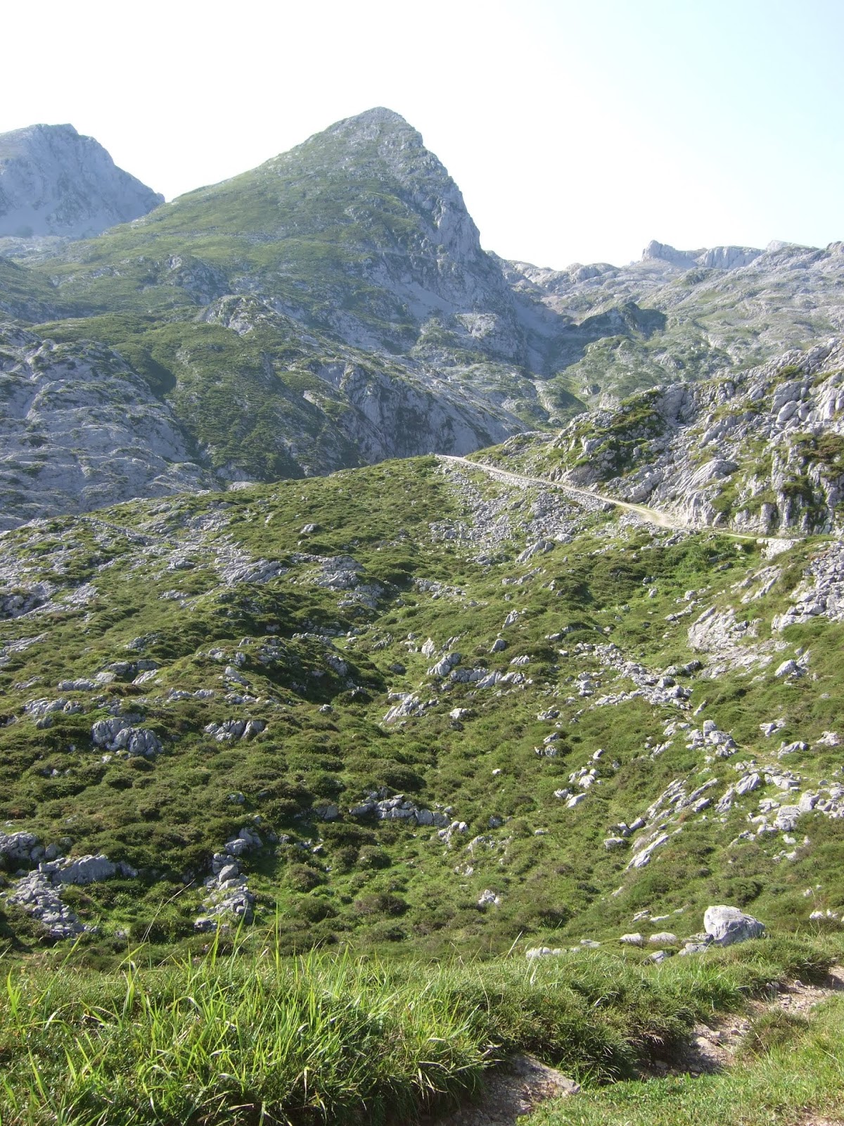
Por último, la Majada de la Jazuca. La Canal de las Vacas sube al refugio hacia la derecha. Yo había subido por la canal que parece formar una continuación de la vega y sube de frente.
Finally, the Majada de la Jazuca. I took the path that goes up straight up the opposite slope, The clearer path to the right goes right up to the refuge.

No hay comentarios:
Publicar un comentario
Please feel free to leave a comment!
¡Agradezco tus comentarios!